

Crantock beach
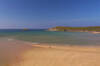
Crantock beach is a dune-backed beach south of Newquay across which the River Gannel runs. Due to the strong currents associated with the tidal river, the northern area of the beach is not recommended for swimming. The best place to swim is towards the southern side, backed by the cliffs of West Pentire.
From West Pentire, there are steps from the coast path leading down to the inlet near the Bowgie Inn and another path leading down at Vugga Cove. However, there is no way up from the cliffs around Piper's Hole at the back of the beach so care should be taken not to be trapped in the inlets here by a rising tide. Currents along the cliffs also sometimes create depressions in the sand which fill up with water as the tide comes in forming deep pools which can result in unwary people being marooned on sandbars.
- Tide times
- Beach info
- Map
- Dogs: allowed all year
Walks visiting Crantock beach
-
2.2 miles/3.6 km - Easy-moderate
West Pentire and Polly Joke

West Pentire and Polly Joke
2.2 miles/3.6 km - Easy-moderate
A circular walk through the poppy fields of West Pentire to Polly Joke beach, returning over the headland to the pub that was a cowshed until the mid-20th Century.
-
2.3 miles/3.7 km - Easy-moderate
Crantock

Crantock
2.3 miles/3.7 km - Easy-moderate
A circular walk along the Gannel Estuary from Crantock Beach to Penpol Creek, returning though the village of Crantock.
-
4.5 miles/7.2 km - Easy-moderate
Crantock and The Gannel

Crantock and The Gannel
4.5 miles/7.2 km - Easy-moderate
A circular walk along the River Gannel from Crantock, originally settled by Celtic monks whose chapel is thought may be buried beneath the dunes.
-
4.9 miles/7.9 km - Easy-moderate
Holywell to Crantock

Holywell to Crantock
4.9 miles/7.9 km - Easy-moderate
A circular walk from Holywell Bay past the remarkable sacred spring and along the coast to the sandy beaches of Porth Joke and Crantock, returning via the poppy fields of West Pentire and the Cubert Common nature conservation area.
-
3.5 miles/5.7 km - Moderate
West Pentire to Crantock Beach

West Pentire to Crantock Beach
3.5 miles/5.7 km - Moderate
A circular walk on the northernmost end of one of Cornwall's largest areas of sand dunes that stretch from Crantock to Perranporth, under which one mediaeval chapel was found and another is said to still be lost.
-
6.9 miles/11.2 km - Moderate
Holywell Bay to Newquay (via bus)

Holywell Bay to Newquay (via bus)
6.9 miles/11.2 km - Moderate
A one-way coastal walk, made circular via an initial bus journey, from Holywell Bay along the coast and Gannel estuary to Newquay, passing the beaches of Porth Joke and Crantock and the headland of West Pentire where there is a spectacular display of red-and-gold wildflowers in June.


Download the iWalk Cornwall app and use the QR scanner within the app to find out more about any of the walks above.