

Harbour Cove
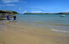
Harbour Cove is the beach on the opposite side of the Camel Estuary from Daymer Bay. There is a beach at all states of the tide at Harbour Cove although at low tide, the vast beach stretches out towards Doom Bar and merges with the other beaches, making it possible to walk around Gun Point to St George's Cove across the sand.
During Victorian times and even during the early 20th Century, the main river channel ran alongside Stepper Point and so there were no sand dunes or sand bars here and the cove was surrounded by rock platforms below the edges of the field. Harbour Cove itself was a tiny beach at the mouth of the inlet in the area which is now marshland with an old double wooden walkway.
Harbour Cove is also known locally as Tregirls beach, named after Tregirls Farm. In 1600, the name was originally "grylls" but was corrupted into "girls" over the years. It's possible the name of the farm arises from the Grylls family who were part of the Cornish gentry.
- Tide times
- Beach info
- Map
- Dogs: allowed all year
Walks visiting Harbour Cove
-
2.5 miles/4 km - Easy-moderate
Stepper Point and the Doom Bar

Stepper Point and the Doom Bar
2.5 miles/4 km - Easy-moderate
A circular walk overlooking the infamous Doom Bar - from which the internationally popular beer is named - on which hundreds of vessels were wrecked when attempting to navigate into Padstow harbour and many still lie beneath the sands
-
3.1 miles/5 km - Easy-moderate
Padstow to Harbour Cove

Padstow to Harbour Cove
3.1 miles/5 km - Easy-moderate
A circular walk through Padstow's mediaeval network of streets to the church, the Elizabethan Manor at Prideaux Place and Tregirls Farm, with panoramic views of the estuary, returning along a mile of sandy beaches.
-
6.4 miles/10.3 km - Easy-moderate
Daymer Bay to Padstow

Daymer Bay to Padstow
6.4 miles/10.3 km - Easy-moderate
A figure-of-8 walk from Daymer Bay thorough the dunes to Rock, passing the once-buried St Enodoc church, before crossing on the ferry to Padstow, and returning along three miles of sandy beaches.
-
6.7 miles/10.7 km - Moderate
Harlyn Bay to Padstow (via bus)

Harlyn Bay to Padstow (via bus)
6.7 miles/10.7 km - Moderate
A one-way coastal walk, made circular via an initial bus journey, from Harlyn Bay to Padstow via Trevone, Stepper Point - where a huge stone tower stands as a daymark, the Doom Bar and the sandy coves of Hawker's, Harbour and St George's which join into a single huge beach at low tide.
-
7.4 miles/12.1 km - Moderate
Trevone to Padstow

Trevone to Padstow
7.4 miles/12.1 km - Moderate
A circular walk to Padstow from Trevone beach, which tracks the route taken by sailing ships along the rugged Atlantic coast to the daymark at Stepper Point, past the infamous Doom Bar and the sandbanks of Hawker's, Harbour and St George's coves before finally reaching safe harbour in Padstow.


Download the iWalk Cornwall app and use the QR scanner within the app to find out more about any of the walks above.