

One-way coastal walks in Cornwall
Enjoy the walks by being guided by the app


These are walks which use public transport to make a one-way walk into a circular route. Currently these are all coastal walks, allowing a 100% coastal route. We always place bus journeys at the start of the walk so you can relax and take your time during the walk without worrying about missing the last bus. Note that these routes overlap with our conventional circular routes so you can choose to do it the way that you prefer (see the "alternatives" section on the page for each walk).
-
4 miles/6.4 km - Easy-moderate
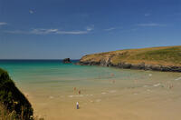
Watergate Bay to Newquay (via bus)

Watergate Bay to Newquay (via bus)
4 miles/6.4 km - Easy-moderate
A one-way coastal walk, made circular via an initial bus journey, from Watergate Bay along the coast path to Newquay, passing the sea caves at Whipsiderry beach, the Iron Age hillfort on Trevelgue head and the beaches of Porth, Lusty Glaze and Tolcarne.
-
6.8 miles/10.9 km - Easy-moderate
Seven Bays (via bus)

Seven Bays (via bus)
6.8 miles/10.9 km - Easy-moderate
A one-way coastal walk, made circular via an initial bus journey, along the Seven Bays coast and around Trevose Head past the lighthouse.
-
4.3 miles/7 km - Moderate
Lelant to St Ives

Lelant to St Ives
4.3 miles/7 km - Moderate
A one-way walk to St Ives along the beaches from Lelant including the vast expanse of Porthkidney Sands, Carbis Bay and Porthminster Beach using the train or bus to make the route almost circular.
-
4.7 miles/7.5 km - Moderate
Perranporth to St Agnes (via bus)

Perranporth to St Agnes (via bus)
4.7 miles/7.5 km - Moderate
A one-way coastal walk, made circular via an initial bus journey, along the ore-bearing cliffs between Perranporth and St Agnes passing the remains of Nobel's dynamite works, Britain's best preserved spitfire base and the Blue Hills of Trevellas Coombe where tin is still processed on a small scale using traditional methods.
-
5.5 miles/8.7 km - Moderate
Boscastle to Tintagel (via bus)

Boscastle to Tintagel (via bus)
5.5 miles/8.7 km - Moderate
A one-way coastal walk, made circular via an initial bus journey, along the dramatic coastline of islands and arches from Boscastle to Tintagel, rated as one of the top five walks in Cornwall.
-
6.7 miles/10.7 km - Moderate
Harlyn Bay to Padstow (via bus)

Harlyn Bay to Padstow (via bus)
6.7 miles/10.7 km - Moderate
A one-way coastal walk, made circular via an initial bus journey, from Harlyn Bay to Padstow via Trevone, Stepper Point - where a huge stone tower stands as a daymark, the Doom Bar and the sandy coves of Hawker's, Harbour and St George's which join into a single huge beach at low tide.
-
6.8 miles/11.0 km - Moderate
Porthcothan, Bedruthan Steps and Watergate Bay (via bus)
Porthcothan, Bedruthan Steps and Watergate Bay (via bus)
6.8 miles/11.0 km - Moderate
A (bus-assisted) one-way walk along the coast with spectacular wildflowers and one of Cornwall's most photographed views over the volcanic rock stacks of Bedruthan Steps, which Victorians liked to think of as a giant's stepping stones.
-
6.9 miles/11.2 km - Moderate
Holywell Bay to Newquay (via bus)

Holywell Bay to Newquay (via bus)
6.9 miles/11.2 km - Moderate
A one-way coastal walk, made circular via an initial bus journey, from Holywell Bay along the coast and Gannel estuary to Newquay, passing the beaches of Porth Joke and Crantock and the headland of West Pentire where there is a spectacular display of red-and-gold wildflowers in June.
-
7.6 miles/12.3 km - Moderate-strenuous
Mevagissey to Charlestown (via bus)

Mevagissey to Charlestown (via bus)
7.6 miles/12.3 km - Moderate-strenuous
A one-way coastal walk, made circular via an initial bus journey, from the fishing port of Mevagissey to Charlestown - one of the best-preserved Georgian ports in the world and an engineering masterpiece which included a seven-mile-long leat.
-
7.7 miles/12.4 km - Moderate-strenuous
Zennor to St Ives (via bus)

Zennor to St Ives (via bus)
7.7 miles/12.4 km - Moderate-strenuous
A fairly demanding but rewarding one-way coastal walk, made circular via an initial bus journey, along the rugged coast between St Ives and Zennor, passing Seal Island which may have given rise to the legend of the mermaid of Zennor and - thanks to some imaginative naming - ice cream (Moomaid of Zennor). The walk is in the optimal direction to remove time pressure and for panoramic views across St Ives bay.
-
9.4 miles/15.1 km - Moderate-strenuous
Port Isaac to Polzeath (via bus)

Port Isaac to Polzeath (via bus)
9.4 miles/15.1 km - Moderate-strenuous
A one-way coastal walk, made circular via an initial bus journey, from Port Isaac to Polzeath along the Rollercoaster Path to Port Quin, the golden beaches of Lundy Bay via the Iron Age hillfort on the twin headland of The Rumps.
-
6.4 miles/10.3 km - Strenuous
Crackington Haven to Widemouth (via bus)

Crackington Haven to Widemouth (via bus)
6.4 miles/10.3 km - Strenuous
A one-way coastal walk, made circular via an initial bus journey, along the Shipwreck Coast from Crackington Haven to Widemouth Bay passing the bluebell woodland of ancient twisted oaks at The Dizzard, chevron folded rocks and honeycomb reefs of Millook Haven and fossil beds of Wanson Mouth.
-
7 miles/11.2 km - Strenuous
Crackington Haven to Boscastle (via bus)

Crackington Haven to Boscastle (via bus)
7 miles/11.2 km - Strenuous
A one-way coastal walk, made circular via an initial bus journey, along the Shipwreck Coast from Crackington Haven to Boscastle passing the highest cliff in Cornwall and the long, sandy beach at The Strangles.
-
9.7 miles/15.6 km - Strenuous
Port Isaac to Tintagel

Port Isaac to Tintagel
9.7 miles/15.6 km - Strenuous
A one-way walk from Port Isaac to Tintagel along towering cliffs, past the long, sandy beaches of Tregardock and Trebarwith, the slate pinnacles of the coastal quarries and via the mediaeval cliff-top church to the castle of Arthurian legend.


Download the iWalk Cornwall app and use the QR scanner within the app to find out more about any of the walks above.
