

Circular walks around Blisland
Enjoy the walks by being guided by the app


-
2.7 miles/4.4 km - Easy-moderate
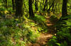
Blisland to Lavethan Wood

Blisland to Lavethan Wood
2.7 miles/4.4 km - Easy-moderate
A short circular walk from the village of Blisland through the churchyard, two stretches of the Woodland Trust reserve of Lavethan Wood and land which was once the estates of Lavethan and Barlandew manors.
-
3.1 miles/5.0 km - Moderate
St Breward to Lank

St Breward to Lank
3.1 miles/5.0 km - Moderate
A short circular walk from St Breward through ancient bluebell woods along the valley of the River Camel to the holy well, ending at the mediaeval church and inn.
-
5.2 miles/8.4 km - Moderate
Poley's Bridge to Blisland

Poley's Bridge to Blisland
5.2 miles/8.4 km - Moderate
A circular walk from Poley's Bridge along the Camel Trail past the old china clay driers to Wenfordbridge and crossing the De Lank valley and Pendrift Downs to Blisland, returning along the Camel valley.
-
4.3 miles/6.9 km - Moderate-strenuous
Blisland and Pendrift Downs

Blisland and Pendrift Downs
4.3 miles/6.9 km - Moderate-strenuous
A circular walk from Blisland through the De Lank granite quarry, used for many famous buildings including the Royal Opera House, between the moss-covered boulders and trees of the De Lank river valley and across the Pendrift Downs, passing Jubilee Rock - a huge granite boulder, decorated with carvings.


Download the iWalk Cornwall app and use the QR scanner within the app to find out more about any of the walks above.
