

Walks around Crackington
Enjoy the walks by being guided by the app


-
3.2 miles/5.1 km - Easy-moderate
Poundstock to Penfound

Poundstock to Penfound
3.2 miles/5.1 km - Easy-moderate
A circular walk along country lanes, tracks and through fields to Penfound Manor - thought to be the oldest continually-inhabited ancestral home in England - from Poundstock church and gildhouse - the only surviving mediaeval church house of its kind in Cornwall.
-
3.4 miles/5.5 km - Easy-moderate
Jacobstow to Poulza

Jacobstow to Poulza
3.4 miles/5.5 km - Easy-moderate
A circular countryside walk around the Saxon area of Jacobstow near Bude where an ancient mediaeval altar was removed from the church during the 16th Century and used as a footbridge over a stream, then used as a churchyard seat in Victorian times, and finally returned to the church in the 1970s.
-
3 miles/4.8 km - Moderate
Millook to Trebarfoote

Millook to Trebarfoote
3 miles/4.8 km - Moderate
A circular walk through Woodland Trust reserves of the ancient Millook woods, meadows to the former smuggling den and 1920s wild party venue of Trebarfoote, and along the coast from Cancleave Strand to Millook Haven where colliding continents have melted and folded the rocks like toffee.
-
3.2 miles/5.2 km - Moderate-strenuous
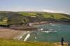
Crackington Haven to St Genny's Church

Crackington Haven to St Genny's Church
3.2 miles/5.2 km - Moderate-strenuous
A circular walk from the surf beach at Crackington Haven to the mediaeval church at St Genny's via the imposing Penkenna Point, where there are spectacular views of the bay and the secluded landing points used by some of North Cornwall's most notorious smugglers and wreckers.
-
4.3 miles/6.9 km - Moderate-strenuous
Crackington Haven to The Strangles

Crackington Haven to The Strangles
4.3 miles/6.9 km - Moderate-strenuous
A circular walk from Crackington Haven, with panoramic views of the Shipwreck Coast, to the long, sandy Strangles beach, returning through bluebell woodland along the Ludon river valley.
-
4.8 miles/7.7 km - Moderate-strenuous
Millook Haven to Dizzard

Millook Haven to Dizzard
4.8 miles/7.7 km - Moderate-strenuous
A circular walk through the Millook woodland reserves to the ancient gnarled oak forest of The Dizzard, returning along the coast with panoramic views to Hartland Point, to the chevron-folded cliffs and honeycomb reefs of Millook Haven.
-
4.9 miles/7.8 km - Moderate-strenuous
The Strangles to Buckator

The Strangles to Buckator
4.9 miles/7.8 km - Moderate-strenuous
A circular walk along the volcanic coastline north of Boscastle, including Cornwall's highest cliff and The Strangles beach with its spectacular arch known as the Northern Door.
-
3.4 miles/5.4 km - Strenuous
Poundstock to Millook

Poundstock to Millook
3.4 miles/5.4 km - Strenuous
A circular walk from Poundstock through bluebell woods along the river to the pretty pebbles and chevron-folded cliffs of Millook Haven and along the coast path with panoramic views from Bridwill Point.
-
4.3 miles/7.0 km - Strenuous
St Gennys Church to Dizzard

St Gennys Church to Dizzard
4.3 miles/7.0 km - Strenuous
A circular walk at St Gennys from the mediaeval church, via the smuggling routes though bluebell woods along the stream and an Iron Age clifftop fort crumbling into the sea, to some of North Cornwall's most remote coastline.
-
6.4 miles/10.3 km - Strenuous
Crackington Haven to Widemouth (via bus)

Crackington Haven to Widemouth (via bus)
6.4 miles/10.3 km - Strenuous
A one-way coastal walk, made circular via an initial bus journey, along the Shipwreck Coast from Crackington Haven to Widemouth Bay passing the bluebell woodland of ancient twisted oaks at The Dizzard, chevron folded rocks and honeycomb reefs of Millook Haven and fossil beds of Wanson Mouth.
-
7 miles/11.2 km - Strenuous
Crackington Haven to Boscastle (via bus)

Crackington Haven to Boscastle (via bus)
7 miles/11.2 km - Strenuous
A one-way coastal walk, made circular via an initial bus journey, along the Shipwreck Coast from Crackington Haven to Boscastle passing the highest cliff in Cornwall and the long, sandy beach at The Strangles.


Download the iWalk Cornwall app and use the QR scanner within the app to find out more about any of the walks above.
