
Circular walks in Cornwall with rhododendrons
Enjoy the walks by being guided by the app


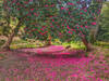
The larger rhododendron trees such as a Menacuddle Well and Pendarves Wood usually flower in mid April. The smaller bushes such as those along the path to Hawk's Tor typically flower a little later, from May.
-
5.3 miles/8.5 km - Easy
Dunmere to Grogley Halt

Dunmere to Grogley Halt
5.3 miles/8.5 km - Easy
A circular walk along the Camel valley from Dunmere Halt to Grogley Halt on the Camel Trail, passing the Camel Valley vineyard and the Boscarne platform where the Bodmin-Wenford steam trains depart.
-
3.2 miles/5.1 km - Easy-moderate
Lanhydrock Gardens

Lanhydrock Gardens
3.2 miles/5.1 km - Easy-moderate
A fairly short and easy circular walk through Lanhydrock gardens with plenty of picnic spots along the River Fowey that you can combine with a visit to the house.
-
3.8 miles/6.1 km - Easy-moderate
Lanhydrock to Respryn

Lanhydrock to Respryn
3.8 miles/6.1 km - Easy-moderate
A circular walk through the mature broadleaf woodland in the less well-known areas of the Lanhydrock estate, through bluebell woods and along the River Fowey, past the mediaeval bridge at Respryn, built after numerous prayers for safe passage in the ford-side chapel, had not resulted in the desired outcome.
-
4.4 miles/7 km - Easy-moderate
Giant's Quoit and Pendarves Wood

Giant's Quoit and Pendarves Wood
4.4 miles/7 km - Easy-moderate
A walk from a tiny village designed by Victorians, through ancient woodland that was once part of the Pendarves Estate to the prehistoric tomb that, despite two collapses over the centuries, is once again standing.
-
5 miles/8 km - Easy-moderate
St Austell, Clay Trails and Menacuddle Well

St Austell, Clay Trails and Menacuddle Well
5 miles/8 km - Easy-moderate
A circular walk in china clay country, including a trail laid on the trackbed of a mineral railway from St Austell to the Cornish Alps and one of Cornwall's most picturesque holy wells.
-
6.2 miles/10 km - Easy-moderate
Gwennap Pit and Carn Marth

Gwennap Pit and Carn Marth
6.2 miles/10 km - Easy-moderate
A circular walk through an area steeped in mining history, with panoramic views from Carn Marth and the almost legendary Gwennap Pit which became so famous that even the neighbouring mine was renamed to Cathedral
-
4.3 miles/6.9 km - Moderate
Treslea Downs and Warleggan

Treslea Downs and Warleggan
4.3 miles/6.9 km - Moderate
A circular walk at one of Cornwall's more remote and eccentric hamlets, displaying a "twinned with Narnia" sign and with a church where the vicar surrounded his rectory with barbed wire and preached to an empty church containing name cards of his parishioners
-
3.7 miles/5.9 km - Moderate-strenuous
North Hill to Hawks Tor

North Hill to Hawks Tor
3.7 miles/5.9 km - Moderate-strenuous
A circular walk along prehistoric trade routes in the Lynher valley from the village of North Hill where the granite was quarried to build Westminster Bridge.
-
5 miles/8.1 km - Moderate-strenuous
Lerryn to St Veep

Lerryn to St Veep
5 miles/8.1 km - Moderate-strenuous
A circular walk from Lerryn, along wooded creeks and across fields, to the church of St Veep, which is the only one in England where the bells were cast in perfect tune.


Download the iWalk Cornwall app and use the QR scanner within the app to find out more about any of the walks above.
