
Circular walks around The Tamar Valley
Enjoy the walks by being guided by the app


-
3.7 miles/6.0 km - Easy-moderate
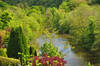
Calstock

Calstock
3.7 miles/6.0 km - Easy-moderate
A walk at Calstock where a Victorian mineral railway from Kelly Bray once ran down to the quayside and the viaduct was built in the 1900s to connect this to Plymouth, creating today's Tamar Valley Line.
-
3.7 miles/5.9 km - Easy-moderate
Newmills to Tregadillett

Newmills to Tregadillett
3.7 miles/5.9 km - Easy-moderate
A circular walk in the Kensey valley from the end of the steam railway at Newmills, through the bluebell woods at Trebursye, to the Eliot Arms in Tregadillett and returning to Newmills via the remains of a prehistoric fort, to catch the steam train back to Launceston.
-
4.1 miles/6.6 km - Easy-moderate
North Petherwin to Winsdon

North Petherwin to Winsdon
4.1 miles/6.6 km - Easy-moderate
A circular walk from North Petherwin in the river valleys of the Bolsbridge Water.
-
4.2 miles/6.8 km - Easy-moderate
Davidstow and Inny Vale

Davidstow and Inny Vale
4.2 miles/6.8 km - Easy-moderate
A circular walk in the Inny Vale on the northern edge of Bodmin Moor through the WW2 airbase on Davidstow Moor, the tunnel of trees to Treworra and past the source of the River Inny to the church and holy well of St David.
-
4.8 miles/7.7 km - Easy-moderate
Saltash and the Lynher Valley

Saltash and the Lynher Valley
4.8 miles/7.7 km - Easy-moderate
A circular walk in the ferry town that was the main riverside settlement in mediaeval times when Plymouth was moorland, and where a handful of Elizabethan buildings still remain from the period when Francis Drake built a property empire from his circumnavigation of the globe.
-
5.1 miles/8.2 km - Easy-moderate
Polyphant

Polyphant
5.1 miles/8.2 km - Easy-moderate
A circular countryside walk to the mills in the Inny Valley from Polyphant, Cornish for "toad pool", to Gimblett's Mill where the bridge was rebuilt after a wall of water swept down the valley in 1847 destroying nearly everything in its path.
-
5.2 miles/8.3 km - Easy-moderate
Tregantle to Crafthole
Tregantle to Crafthole
5.2 miles/8.3 km - Easy-moderate
A circular walk in tributary valleys of the St Germans River and past the Victorian coastal defences overlooking Whitsand Bay, where one of the forts is still in use today.
-
2.5 miles/4 km - Moderate
Danescombe Valley

Danescombe Valley
2.5 miles/4 km - Moderate
A circular walk from Cotehele Quay into the broadleaf woodland of the Danescombe Valley where bluebells and orchids flower in spring and fungi erupt through the carpet of autumn leaves.
-
3 miles/4.8 km - Moderate
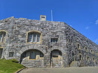
Cremyll to Maker Church

Cremyll to Maker Church
3 miles/4.8 km - Moderate
A circular walk on a peninsula protruding into the Hamoaze estuary and where the land was dotted with gun batteries, defending against a potential invasion from Napoleon.
-
3.6 miles/5.8 km - Moderate
Portwrinkle to Sheviock

Portwrinkle to Sheviock
3.6 miles/5.8 km - Moderate
A circular walk from the beach and tiny harbour of Portwrinkle to the small village of Sheviock, thought to be Cornish for "abounding in strawberries", with a church abounding in mediaeval tombs.
-
3.9 miles/6.2 km - Moderate
Cotehele to Metherell

Cotehele to Metherell
3.9 miles/6.2 km - Moderate
A circular walk via the quays, woods, engine house and mills of the Cotehele Estate where by Georgian times the house had become a tourist attraction because it was so antiquated, and has changed little since.
-
4.2 miles/6.8 km - Moderate
St Dominic to Cotehele Bridge

St Dominic to Cotehele Bridge
4.2 miles/6.8 km - Moderate
A figure-of-eight walk from St Dominic along the wooded valley to the quays of Bohetherick and Cotehele, where limestone and coal were continuously fed into kilns to produce lime for the market gardens in the Tamar Valley.
-
4.2 miles/6.7 km - Moderate
Werrington to Bridgetown

Werrington to Bridgetown
4.2 miles/6.7 km - Moderate
A circular walk through two tributary valleys of the River Tamar in a parish that was borrowed by Devon for 800 years, passing the remains of the wharf at the furthest reaches of the Bude Canal.
-
5.6 miles/9.0 km - Moderate
Rame Head and Cawsand

Rame Head and Cawsand
5.6 miles/9.0 km - Moderate
A circular walk around Rame Head - the southeastern corner of Cornwall - past the mediaeval chapel and the remains of a huge gun battery, now a nature reserve, on Penlee Point to Cawsand which was once the smuggling capital of Cornwall.
-
5.6 miles/9.0 km - Moderate
St Clether to the Rising Sun

St Clether to the Rising Sun
5.6 miles/9.0 km - Moderate
A figure-of-8 walk from St Clether past the ancient chapel and holy well, with views over the Inny Valley, to the Rising Sun pub near Altarnun, serving beer made from the moorland springwater by a local micro-brewery.
-
5.7 miles/9.1 km - Moderate
Mount Edgcumbe to Kingsand

Mount Edgcumbe to Kingsand
5.7 miles/9.1 km - Moderate
A circular walk though the Mount Edgcumbe Country Park to Kingsand with views over Plymouth Sound including Drake's Island where Drake set sail to circumnavigate the globe, and the breakwater which Napoleon described as an engineering masterpiece as he left England on his prison ship.
-
5.9 miles/9.5 km - Moderate
Cotehele to Calstock

Cotehele to Calstock
5.9 miles/9.5 km - Moderate
A circular walk through the gardens of Cotehele to Calstock where Cornwall's largest Roman fort once stood, the Vikings allied with the Cornish to fight off the Saxons, and more recently railway wagons were lifted over 100ft by steam power from the quay to the top of the viaduct.
-
6.6 miles/10.6 km - Moderate
Inny Valleys from Altarnun

Inny Valleys from Altarnun
6.6 miles/10.6 km - Moderate
A circular walk around the valleys of the River Inny and Penpont Water to the mediaeval church at Laneast and the old bridge at Gimblett's Mill from the 15th century "Cathedral of the Moors" in Altarnun, set beside a 6th Century Celtic cross where churches and chapels had been throughout the Dark Ages.
-
3.7 miles/5.9 km - Moderate-strenuous
North Hill to Hawks Tor

North Hill to Hawks Tor
3.7 miles/5.9 km - Moderate-strenuous
A circular walk along prehistoric trade routes in the Lynher valley from the village of North Hill where the granite was quarried to build Westminster Bridge.
-
4.5 miles/7.2 km - Moderate-strenuous
Rilla Mill and Plushabridge

Rilla Mill and Plushabridge
4.5 miles/7.2 km - Moderate-strenuous
A circular walk from Rilla Mill with views across Cornwall to the Cheesewring and Kit Hill, and along the River Lynher through the Colquite Woodland reserve and via medieval bridges to where the ancient mill stood until the 1960s and the leats can still be seen.


Download the iWalk Cornwall app and use the QR scanner within the app to find out more about any of the walks above.
