
FAQ for the iWalk Cornwall app
Contents
Buying walks
For troubleshooting any issues buying walks see the platform-specific troubleshooting guide either for Apple or Android.
What's included in the price?
Each walk includes the following:
- Detailed, triple-tested and continually-maintained directions. We periodically re-walk every route ourselves and update the directions. A group of volunteers also continually feed back changes to the routes.
- A GPS-accurate map of the route showing exactly where you are and which way you are facing at all times.
- Local information on the history, landscape and wildlife along the route. We've researched over 3,000 topics and done over a decade of fieldwork, recording the wildlife present along each route. Each walk includes a minimum of 25 points of interest and most walks have significantly more. A typical walk contains the information equivalent to a 40-50 page guidebook tailored to just what's relevant to that specific route.
- When you do a walk, the app automatically adapts its natural history information to be seasonally-relevant. It knows when many common flowers start and stop flowering and adjusts the content accordingly based on local knowledge from fieldwork at each of the locations within the directions. Doing a walk in the spring you may get info about bluebells on a woodland section. Doing the same walk in autumn, you may get info about fungi.
- Information about the route that allows the app to accurately track distance travelled, estimate time left based on your walking speed and count down distance to the next direction point as you walk along. If you are walking in the evening it also calculates the time of dusk and warns you if it looks likely that you'll run out of light.
- Smart off-route warnings, tailored from local knowledge to give you enough freedom to explore points of interest without "computer says no".
- Information about the dog-friendliness of stiles so you know in advance if you're likely to need to lift a large dog.
- Info about which beaches on the route have dog restrictions. There's also a nearest vet button for emergencies.
- Recommendations for footwear and seasonally-activated mud warnings for routes that get particularly muddy.
- Info on temporary footpath issues such as closures, diversions, fallen trees etc.
- Tide times at the nearest observation point to that walk for maximum accuracy.
- The pubs on the route with links to the pub website for opening times, menus etc.
- Integration with Google and Apple maps for information about nearest toilets, refreshments and shops whilst you are walking, and also using the general walk location before the walk so you can explore and make plans before you are there.
- A walk overview including length and steepness grade to assist with walk planning. Descriptive information about the gradients on the route is also included - how far around the route the climbs are and if there are any particularly steep descents.
- Integration with driving satnav to direct you to the car park at the start of the walk. A range of satnav apps are supported including Waze as well as the built-in Google and Apple maps. What3words format is also available for input into in-car satnavs.
- Seasonal metadata to allow walks to be selected for the time of year - seasonal lists of walks (e.g. walks with cool shade) automatically appear in "Walks by type" at the relevant time of year.
- Countryside tips such as walking with livestock. There's also info about how to contribute wildlife sightings to help with scientific research.
- Information within each walk direction to help the Cornwall Council Countryside Access Team (who maintain the rights of way network) pinpoint issues and an easy mechanism to report these that even works without a phone signal so everyone can participate in making the paths better for each other.
- Free updates. As well as the walk directions being continually updated for changes to the paths, more local information about points of interest is also being continually added.
What payment methods can I use to buy a walk?
- On an Apple device, see the payment methods supported by Apple
- On Android, see the payment methods supported by Google Play
If I change phones, will I have access to my walks?
Your walks are in-app purchases from Apple or Google which they store into your Apple account or Google account alongside any apps you've bought from the App Store/Google Play. You can use the relevant link below to check what's in your Apple/Google account:
Provided your new phone is on the same platform as your old phone and is signed into the platform with the same Apple/Google account, then the app will be able to download the walks from Apple/Google to your new device. You can also use the same approach to share walks between your phone and tablet (provided they are on the same platform).
Note that Apple and Google currently don't provide a mechanism to transfer in-app purchases either between accounts on the same platform or to their rival's platform (i.e. they do NOT support moving in-app purchases from iPhone to Android or vice versa). As stated in the terms of use, you therefore can't access walks purchased from Apple on an Android phone or vice versa.
If you've changed platforms, note that the iWalk Cornwall app doesn't need a SIM card so you can still use your old phone for the walks you've purchased on that platform and you can still get free updates for those walks over WiFi.
Can I share walks with a family member?
Apple/Google make in-app purchases available to any devices signed-in to the platform with the SAME account. The app will fetch these from your Apple ID/Google account when it starts.
Cross-account sharing ("family sharing" / "family library") of walks is currently not possible.
Navigating routes
Can I do the circular walk starting from part-way round the route?
Yes, bearing the following in mind:
- When you reach a direction point on the route, the app will offer to start the walk from here (accept).
- Follow the walk until you reach what is normally the end of the route.
- The wording of the last and first directions will be to/from the car park so you'll need to use a bit of common sense (and the map) to make your way from the last direction to direction 1 to join up the circle.
- Once you reach direction 1, the app will ask if you want to continue navigating from here to where you started the route (accept).
- When reading the wording for direction 1, bear in mind that initially you probably won't be facing the same way as if you'd just come from the car park so rotate yourself accordingly before attempting to interpret "left" and "right" in direction 1.
- When you reach the direction where you started the route, the app will ask if you want to make the walk as completed.
There's some more info here.
Can I do the walk in the opposite direction?
This is not possible because - like a walking book - the direction wording/landmarks and geolocation are all hand-crafted, predicated on doing the walk in a particular direction. Unlike a car satnav which can auto-generate simplistic directions from a database of road vectors because the road environment is very highly regulated and consistent, the countryside is - in a very big way - neither of these things. Therefore highly descriptive directions using visual landmarks are required to recognise where the path actually is, let alone which way to go.
This information is triple-tested in the field which already requires a substantial amount of effort. An alternative set of directions for the reverse route would require the same level of testing as in the reverse direction, many of the decision points are in different places and the landmarks all look different. This would nearly double not only the initial production cost but the ongoing maintenance costs of the route navigation information. It already takes roughly three years to work through all the routes re-checking them. Doubling this would lead to an unacceptable loss of accuracy of the walks.
The map screen will track your position even if you aren't following the directions so it technically is possible to navigate backwards using just the map but it's not really the same thing as following directions and being warned if you're off route. In general, starting a route part-way round and following it in the written direction (described above) is the better option.
Can I use the app to navigate along footpaths which are not part of the walk route?
As well as the obvious lack of directions, this is not recommended:
- All other paths you're likely to notice are shown on the map within the app to help you find your bearings when you are on the route. Not all of these have public rights of way. Their presence on the map does not imply a right of way. You should consult an OS map or the Cornwall Council mapping service if you want to determine if there is a public or permissive right of way along a footpath not on the walk route.
- Paths which are not on the route have not been checked for positional accuracy to the level that the paths forming the route have.
Can I do walks using public transport?
The app can be used to get Google/Apple maps to show the nearest bus stops to the start of the walk.
You'll need to use your own judgement and initiative to:
- assess the available bus stops based on the ease of walking from each to join the walk route, or decide if a different walk or driving to the parking location would be preferable.
- navigate from a bus stop to reach the route. One option is to use the driving directions button to get Google Maps to navigate you to the start of the walk and then to switch Google maps into walking mode but bear in mind that Google may still send you along busy roads.
If the way you walk from the bus stop passes through a direction point on the route before you reach the normal start of the walk, the app will offer to start the walk part-way around so you can do the circular walk from here instead.
How long will the walk take?
To estimate that, you'll need to work out your personal average walking speed which will be somewhere in the range 1-3 mph and then you can divide the length shown on the walk by this. The app calculates this as you walk along and uses this to estimate the time remaining for the walk. It's also shown at the end when the walk is completed so you can build up a picture of how fast you walk to be able to do rough estimations yourself. You'll also find it will vary with season (muddy paths slow you down, as does hot weather and vegetation).
Why does my GPS tracker say the walk is longer?
Whilst the iWalk Cornwall app knows the exact route and can therefore accurately measure its length, your GPS tracker has to estimate distance based on GPS positions. Each GPS reading contains several metres of error. The resulting accumulation of errors can result an overestimate of distance around 10-20%. There's a fuller explanation here.
What does the walk grade correspond to?
The scale is based on walk steepness:
- 1: Easy - no steep gradients
- 2: Easy-Moderate - some gradients but nothing too steep or long
- 3: Moderate - involves some steepish gradients but OK for anyone of average fitness
- 4: Moderate-Strenuous - some "proper" steep gradients; likely to be hard going unless you are fairly fit
- 5: Strenuous - lots of "proper" steep gradients; don't attempt unless you are fit
Note that the grade of the walk is based only on steepness and not length to give the option of selecting longer walks without any really steep bits. For an "exhaustingness" scale, take into account both the steepness grade and the length and also the weather (both in terms of heat and mud). Also bear in mind anything listed challenges section that might be relevant to you to get an overall idea of how challenging the walk might be.
Also note that because iWalk Cornwall is exclusive to Cornwall, the steepness grades are on a local scale running from “easy” (for Cornwall) to “strenuous” (as it gets in Cornwall) with the majority still falling the middle at “moderate”. Very little of Cornwall is flat so bear in mind that the easier walks here are not equivalent to walking in a flat area such as the Thames Valley or Norfolk. Conversely the most strenuous walks are not as strenuous as some in mountainous areas such as Scotland or the Lake District.
Suitability for pushchairs or wheelchairs
See the Access on Wheels section on the Accessibility page.
Phones and batteries
Does the app work offline without any wifi/mobile data/internet?
Yes. You only need internet to buy a walk. Once downloaded, the entire walk can be navigated without any internet. If internet happens to be available, a few extra "bells and whistles" are available such as photos for some of the facts, but all the core functionality - including the directions and map - works completely offline.
What if my phone crashes during the walk?
If this happens and you had the iWalk app running at the time, it will remember which direction you got to. When you restart your phone and run the app again, you can continue from where you were.
What can I do to avoid running out of battery?
The GPS circuitry and numerical processing that the phone operating system has to do for GPS is quite power-hungry. There's not much the app can do about that as GPS is the whole point. The app keeps its own CPU footprint to a minimum by only redrawing the map after you've moved more than a certain distance.
A fully-charged phone battery that isn't too old and degraded will typically last a walk. However we strongly recommend investing in an external battery and taking this along as a backup. This is often described as a "complete no-brainer" as, for around £20, you can get something with many times the capacity of the phone's battery so you can walk from dawn until dusk without worrying about battery capacity ever again.
The app monitors how fast your battery is draining throughout the walk and if it looks like it's going to run out before you finish the walk, it will remind you to plug in your external battery or offer you some options to conserve battery power if you're caught short.
Some more tips you can use to eek-out your battery are:
- The phone camera is very power hungry so if you are planning to take lots of photos, using a separate camera or getting your friend to take photos on their phone instead will save a lot of battery.
- Switch off WiFi before setting out on the walk as this uses battery power and isn't much use on a footpath. You can also turn off bluetooth unless you are using it to connect a smartwatch.
- The screen is a significant drain on the battery, so:
- Dim your screen as much as you can get away with, although for viewing outside you'll need it brighter than for inside.
- During the walk, switch the screen off (usually by pressing the power button) during long stretches between directions. The iWalk app will continue to run in the background, even when your screen is turned off, so will still beep/vibrate when there's a new direction to follow.
- If you stop to explore somewhere for a while during the walk, you can use the "Pause GPS" button to pause location tracking which will save battery power. It can be found by pressing the extended menu button "...". Don't forget to press it again to re-enable it before you resume the walk!
Can I print out a hardcopy of the directions as a backup?
Yes. At the bottom of the summary screen of the purchased walk is a PDF of the directions. To print this from your phone, see one of the guides below:
Misc
How do I add a missing place/correct info for nearby amenities?
Both Google and Apple maps allow missing places to be added or existing information to be corrected. See the link for the relevant platform:
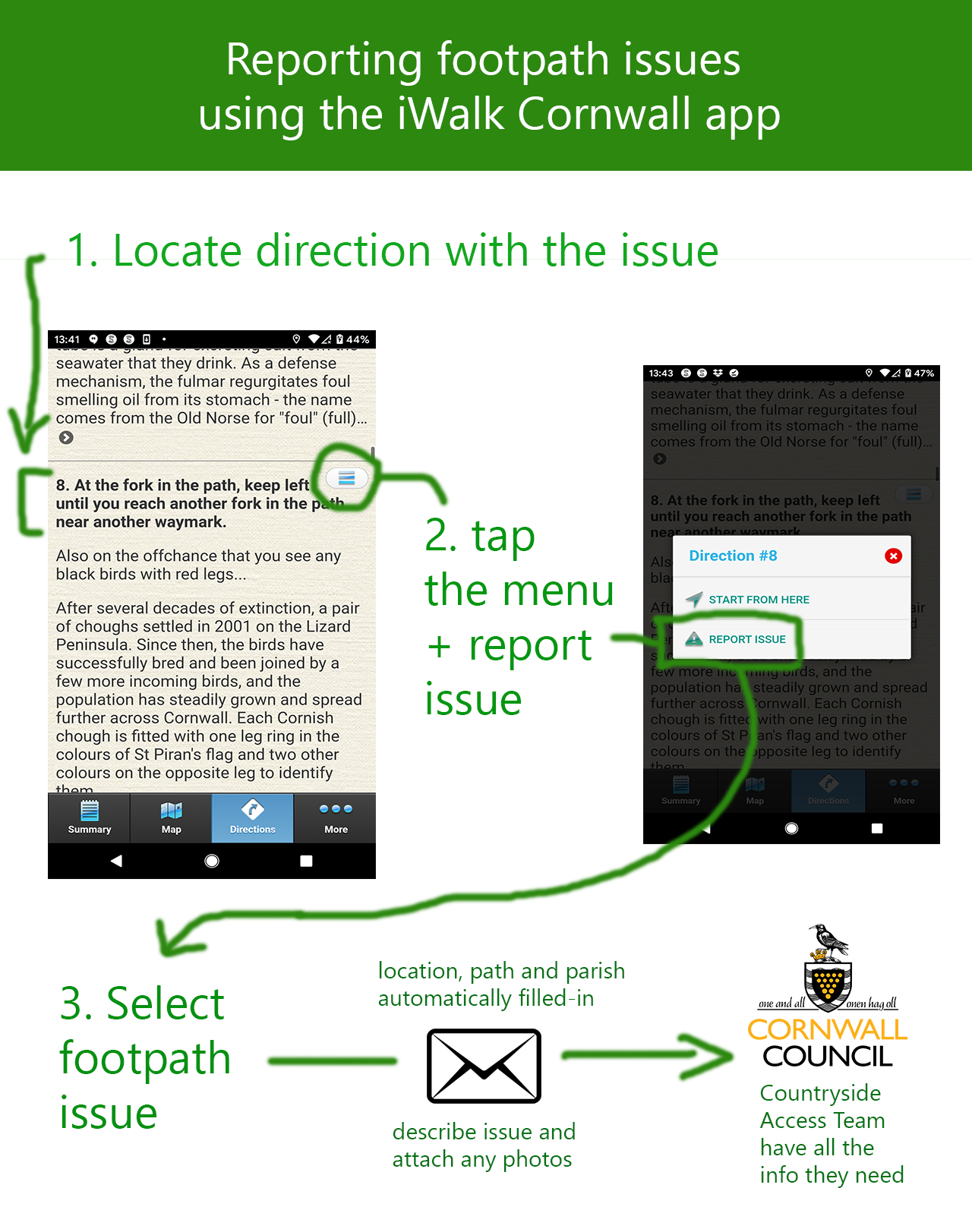
How do I report footpath issues?
The app knows the footpath number and parish details for each direction, so by triggering a report from a direction number where the problem has been spotted, it can fill all this information in automatically in an email for the Cornwall Council Countryside Access Team (who maintain the footpaths).
How do I manually mark a walk as completed?
Normally the app will be able to detect you've reached the end of the walk and offer to complete it, but if you accidently press "no", miss the end of the walk by re-starting from doing it part=way round, the walk can be manually marked as completed by long-pressing on the walk in the My Walks listing until a green "complete" appears on the right, then tap that.
Are you planning to do walks for another county?
Our walks/app will remain exclusive to Cornwall for the foreseeable future for two main reasons. The first is that because creating a walk for the app is a very involved and technical process, creating the walks in Cornwall has taken us over a decade so far and there are still more walks we'd like to add so there are at least a few more years of work left. The other is that it's already a lot of driving to check out reported issues and a huge amount of time to keep the walks constantly updated for changes to footpaths. It wouldn't be possible to maintain that level of quality over larger distances. It's a bit like having 300 children - they always need attention and sometimes they are naughty but they are all very much loved.
Other tips for using the app
There are some tips here.