
Circular walks in Southeast Cornwall
Enjoy the walks by being guided by the app


-
3 miles/4.8 km - Easy-moderate
Looe woodland, river and coast

Looe woodland, river and coast
3 miles/4.8 km - Easy-moderate
A walk following the West Looe river from woods to its confluence and then to meet the Atlantic beside one of Cornwall's mediaeval ports.
-
3.7 miles/6.0 km - Easy-moderate
Calstock

Calstock
3.7 miles/6.0 km - Easy-moderate
A walk at Calstock where a Victorian mineral railway from Kelly Bray once ran down to the quayside and the viaduct was built in the 1900s to connect this to Plymouth, creating today's Tamar Valley Line.
-
3.7 miles/5.9 km - Easy-moderate
Lerryn River and Tivoli lost gardens

Lerryn River and Tivoli lost gardens
3.7 miles/5.9 km - Easy-moderate
A woodland and riverside walk at Lerryn - thought to be the inspiration for the book The Wind In The Willows - and the lost pleasure gardens of Tivoli Park
-
4.5 miles/7.2 km - Easy-moderate
Cardinham Woods and Lady Vale
Cardinham Woods and Lady Vale
4.5 miles/7.2 km - Easy-moderate
A circular walk in the wooded valley surrounding Cardinham Water where the mediaeval chapel of St Mary de Valle once stood but now only the Lady Vale mediaeval bridge remains.
-
4.8 miles/7.7 km - Easy-moderate
Saltash and the Lynher Valley

Saltash and the Lynher Valley
4.8 miles/7.7 km - Easy-moderate
A circular walk in the ferry town that was the main riverside settlement in mediaeval times when Plymouth was moorland, and where a handful of Elizabethan buildings still remain from the period when Francis Drake built a property empire from his circumnavigation of the globe.
-
5 miles/8 km - Easy-moderate
Minions and Caradon Hill

Minions and Caradon Hill
5 miles/8 km - Easy-moderate
A walk through the remains of the UK's most productive copper mines which employed thousands of people in Victorian times, including brakemen who each scooted an individual loaded ore wagon down to Liskeard on the railway that forms much of the walk route.
-
5.1 miles/8.3 km - Easy-moderate
Deerpark to Herodsfoot

Deerpark to Herodsfoot
5.1 miles/8.3 km - Easy-moderate
A woodland walk in what's likely to have been a mediaeval deer park to the site of Cornwall's second-largest gunpowder manufacturing operation, which despite exploding several times was sufficiently successful to give rise to a nearby sister site known as Trago Mills.
-
5.2 miles/8.3 km - Easy-moderate
Tregantle to Crafthole
Tregantle to Crafthole
5.2 miles/8.3 km - Easy-moderate
A circular walk in tributary valleys of the St Germans River and past the Victorian coastal defences overlooking Whitsand Bay, where one of the forts is still in use today.
-
6.1 miles/9.8 km - Easy-moderate
Golitha Falls and Siblyback Lake

Golitha Falls and Siblyback Lake
6.1 miles/9.8 km - Easy-moderate
A circular walk through the Golitha Falls National Nature Reserve along ancient rights of way to pass around Siblyback Lake, where the remains of a mediaeval field system rise from the water when reservoir levels fall.
-
7.3 miles/11.7 km - Easy-moderate
Golitha Falls to Trethevy Quoit

Golitha Falls to Trethevy Quoit
7.3 miles/11.7 km - Easy-moderate
A circular walk through the Golitha Falls National Nature Reserve, to King Doniert's Stone - a memorial to the last King of Cornwall, and the prehistoric tomb of Trethevy Quoit, returning via St Cleer where the holy well is reputed to cure madness.
-
2.5 miles/4 km - Moderate
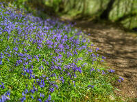
Danescombe Valley

Danescombe Valley
2.5 miles/4 km - Moderate
A circular walk from Cotehele Quay into the broadleaf woodland of the Danescombe Valley where bluebells and orchids flower in spring and fungi erupt through the carpet of autumn leaves.
-
2.4 miles/3.9 km - Moderate
Palace Cove and Lansallos

Palace Cove and Lansallos
2.4 miles/3.9 km - Moderate
A circular walk to the small coves of Lantivet Bay used in Victorian times for pilchard fishing, collecting seaweed as fertiliser and smuggling barrels of French brandy.
-
2.8 miles/4.5 km - Moderate
Two Coombes of Lansallos

Two Coombes of Lansallos
2.8 miles/4.5 km - Moderate
A circular walk from Lansallos to the coves of Lantivet Bay where farmers collected seaweed and sand to improve the soil and smugglers landed French brandy.
-
2.9 miles/4.7 km - Moderate
Polperro harbour and headlands

Polperro harbour and headlands
2.9 miles/4.7 km - Moderate
A figure-of-eight walk around the fishing village and headlands surrounding Polperro, passing the net loft perched above the harbour, the Victorian sea pool, the site of the mediaeval chapel and the harbourmaster's route to the lighthouse.
-
3 miles/4.8 km - Moderate
Cremyll to Maker Church

Cremyll to Maker Church
3 miles/4.8 km - Moderate
A circular walk on a peninsula protruding into the Hamoaze estuary and where the land was dotted with gun batteries, defending against a potential invasion from Napoleon.
-
3.1 miles/4.9 km - Moderate
Kilminorth Woods and the Giant's Hedge

Kilminorth Woods and the Giant's Hedge
3.1 miles/4.9 km - Moderate
A woodland walk alongside the West Looe River where the Giant's Hedge once divided kingdoms of the Dark Ages, centuries before the ancient trees that now tower above it were even seedlings.
-
3.6 miles/5.8 km - Moderate
Portwrinkle to Sheviock

Portwrinkle to Sheviock
3.6 miles/5.8 km - Moderate
A circular walk from the beach and tiny harbour of Portwrinkle to the small village of Sheviock, thought to be Cornish for "abounding in strawberries", with a church abounding in mediaeval tombs.
-
3.8 miles/6.8 km - Moderate
Minions and the Cheesewring

Minions and the Cheesewring
3.8 miles/6.8 km - Moderate
A circular walk around the iconic landmarks at Minions, including The Hurlers stone circles, The Cheesewring and the engine houses of the South Phoenix Mine.
-
3.9 miles/6.2 km - Moderate
Cotehele to Metherell

Cotehele to Metherell
3.9 miles/6.2 km - Moderate
A circular walk via the quays, woods, engine house and mills of the Cotehele Estate where by Georgian times the house had become a tourist attraction because it was so antiquated, and has changed little since.
-
4.2 miles/6.8 km - Moderate
St Dominic to Cotehele Bridge

St Dominic to Cotehele Bridge
4.2 miles/6.8 km - Moderate
A figure-of-eight walk from St Dominic along the wooded valley to the quays of Bohetherick and Cotehele, where limestone and coal were continuously fed into kilns to produce lime for the market gardens in the Tamar Valley.
-
4.3 miles/6.9 km - Moderate
Treslea Downs and Warleggan

Treslea Downs and Warleggan
4.3 miles/6.9 km - Moderate
A circular walk at one of Cornwall's more remote and eccentric hamlets, displaying a "twinned with Narnia" sign and with a church where the vicar surrounded his rectory with barbed wire and preached to an empty church containing name cards of his parishioners
-
4.7 miles/7.6 km - Moderate
Cardinham and Bury Castle

Cardinham and Bury Castle
4.7 miles/7.6 km - Moderate
A circular walk in the tributary valleys of Cardinham Water to the remains of the Bury Castle hill fort where the ramparts are still over 14ft high even after more than 2000 years.
-
5 miles/8 km - Moderate
Caradon Hill to Trethevy Quoit

Caradon Hill to Trethevy Quoit
5 miles/8 km - Moderate
A circular walk in the valley of the River Seaton to the Neolithic tomb from the copper mines of Caradon Hill where the brittle ore could not be usefully crushed by machine so teenage girls were used instead to break the ore with hammers.
-
5 miles/8 km - Moderate
Lantivet Bay and Lansallos

Lantivet Bay and Lansallos
5 miles/8 km - Moderate
A circular walk above the white sand crescent of Lantic Bay and the small coves of Lantivet Bay where a battle was once fought between smugglers and Customs men, and following an ancient cart track along the stream through the woods to the mediaeval church of Lansallos.
-
5.1 miles/8.2 km - Moderate
Lerryn to St Winnow

Lerryn to St Winnow
5.1 miles/8.2 km - Moderate
A circular walk to the creekside church of St Winnow along the River Fowey and Lerryn where hoards of Roman coins have been found on the river banks, and overlooked by the manor house that is thought may have been the inspiration for Toad Hall in The Wind in the Willows.
-
5.3 miles/8.6 km - Moderate
Kit Hill to Kelly Bray

Kit Hill to Kelly Bray
5.3 miles/8.6 km - Moderate
A circular walk in Kit Hill Country Park, given to the county by the Duchy to mark the birth of Prince William and where a midsummer bonfire is lit to celebrate the ancient Celtic Golowan festival
-
5.6 miles/9.0 km - Moderate
Rame Head and Cawsand

Rame Head and Cawsand
5.6 miles/9.0 km - Moderate
A circular walk around Rame Head - the southeastern corner of Cornwall - past the mediaeval chapel and the remains of a huge gun battery, now a nature reserve, on Penlee Point to Cawsand which was once the smuggling capital of Cornwall.
-
5.7 miles/9.1 km - Moderate
Mount Edgcumbe to Kingsand

Mount Edgcumbe to Kingsand
5.7 miles/9.1 km - Moderate
A circular walk though the Mount Edgcumbe Country Park to Kingsand with views over Plymouth Sound including Drake's Island where Drake set sail to circumnavigate the globe, and the breakwater which Napoleon described as an engineering masterpiece as he left England on his prison ship.
-
5.8 miles/9.3 km - Moderate
Pelynt and the West Looe Valley

Pelynt and the West Looe Valley
5.8 miles/9.3 km - Moderate
A circular walk in the West Looe valley near St Nun's Well where it is said that if a bent pin is not left as an offering, clouds of piskies will accompany the visitor home and cause mischief.
-
5.9 miles/9.5 km - Moderate
Cotehele to Calstock

Cotehele to Calstock
5.9 miles/9.5 km - Moderate
A circular walk through the gardens of Cotehele to Calstock where Cornwall's largest Roman fort once stood, the Vikings allied with the Cornish to fight off the Saxons, and more recently railway wagons were lifted over 100ft by steam power from the quay to the top of the viaduct.
-
6.2 miles/10 km - Moderate
East Moor and Lynher Valleys

East Moor and Lynher Valleys
6.2 miles/10 km - Moderate
A circular walk in one of the less well-known areas of Bodmin Moor to the summit of Fox Tor and through the prehistoric remains which date from the Bronze Age and Neolithic times.
-
6.5 miles/10.5 km - Moderate
Duloe to Herodsfoot

Duloe to Herodsfoot
6.5 miles/10.5 km - Moderate
A circular walk through the woodland along the West Looe River to Herodsfoot from Duloe, where Cornwall's smallest stone circle stands.
-
2.5 miles/3.9 km - Moderate-strenuous
Talland Bay to Polperro

Talland Bay to Polperro
2.5 miles/3.9 km - Moderate-strenuous
A circular walk between Talland Bay and Polperro along an area of coastline so famous for smuggling that there is even a museum on the subject.
-
3.7 miles/5.9 km - Moderate-strenuous
North Hill to Hawks Tor

North Hill to Hawks Tor
3.7 miles/5.9 km - Moderate-strenuous
A circular walk along prehistoric trade routes in the Lynher valley from the village of North Hill where the granite was quarried to build Westminster Bridge.
-
4.2 miles/6.8 km - Moderate-strenuous
Polruan to Lantic Bay

Polruan to Lantic Bay
4.2 miles/6.8 km - Moderate-strenuous
A circular walk along the coast from Polruan to the white sandy beaches of Lantic Bay, returning via Lanteglos Church and along the creek with panoramic views of Fowey.
-
4.5 miles/7.2 km - Moderate-strenuous
Gunnislake to Chilsworthy

Gunnislake to Chilsworthy
4.5 miles/7.2 km - Moderate-strenuous
A circular walk in the Tamar Valley at Gunnislake where Victorian canal systems, engine houses and tramways have been recolonised by nature and kingfishers rather than barges now journey up and down the river.
-
4.5 miles/7.2 km - Moderate-strenuous
Rilla Mill and Plushabridge

Rilla Mill and Plushabridge
4.5 miles/7.2 km - Moderate-strenuous
A circular walk from Rilla Mill with views across Cornwall to the Cheesewring and Kit Hill, and along the River Lynher through the Colquite Woodland reserve and via medieval bridges to where the ancient mill stood until the 1960s and the leats can still be seen.
-
5 miles/8.1 km - Moderate-strenuous
Lerryn to St Veep

Lerryn to St Veep
5 miles/8.1 km - Moderate-strenuous
A circular walk from Lerryn, along wooded creeks and across fields, to the church of St Veep, which is the only one in England where the bells were cast in perfect tune.
-
5.1 miles/8.2 km - Moderate-strenuous
St Neot Two Valleys

St Neot Two Valleys
5.1 miles/8.2 km - Moderate-strenuous
A circular walk from St Neot though the valley of the River Loveny, past a prehistoric settlement, through bluebell woodland and along the River Fowey, and returning via the church, famous for its mediaeval stained-glass.
-
6 miles/9.6 km - Moderate-strenuous
Seaton to Millendreath

Seaton to Millendreath
6 miles/9.6 km - Moderate-strenuous
A circular walk in an area of Cornwall so off the beaten track that No Man's Land is a real place name and a breeding colony of monkeys live in the woodland, in a sanctuary set up by the father of the classical guitarist, John Williams.
-
6.7 miles/10.8 km - Moderate-strenuous
Portwrinkle to Downderry

Portwrinkle to Downderry
6.7 miles/10.8 km - Moderate-strenuous
A circular walk around Whitsand Bay to Downderry from Portwrinkle, where the ghost of Silas Finn is said to haunt the cliffs.
-
6.8 miles/10.9 km - Moderate-strenuous
Talland Bay to Looe

Talland Bay to Looe
6.8 miles/10.9 km - Moderate-strenuous
A circular walk along the coast from Talland Bay to Looe, passing the pilgrimage site of Looe Island which Jesus was said to have visited as a child, and returning via the ancient Giant's Hedge in Kilminorth Wood and Talland's mediaeval church.
-
7.1 miles/11.5 km - Strenuous
Polperro to Lansallos

Polperro to Lansallos
7.1 miles/11.5 km - Strenuous
A circular walk along the rugged coast from Polperro, where a bell buoy rings out across the waves from the treacherous reef known as Udder Rock.


Download the iWalk Cornwall app and use the QR scanner within the app to find out more about any of the walks above.
