
Circular walks in the South Coast Eastern National Landscape Area
Enjoy the walks by being guided by the app


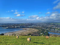
Consists of the Fowey Ria and its tributaries, extending from Gribbin Head to Polperro. Features the ria landscape of the River Fowey with steep wooded slopes and the open coastal areas.
-
3.7 miles/5.9 km - Easy-moderate
Lerryn River and Tivoli lost gardens

Lerryn River and Tivoli lost gardens
3.7 miles/5.9 km - Easy-moderate
A woodland and riverside walk at Lerryn - thought to be the inspiration for the book The Wind In The Willows - and the lost pleasure gardens of Tivoli Park
-
2.4 miles/3.9 km - Moderate
Palace Cove and Lansallos

Palace Cove and Lansallos
2.4 miles/3.9 km - Moderate
A circular walk to the small coves of Lantivet Bay used in Victorian times for pilchard fishing, collecting seaweed as fertiliser and smuggling barrels of French brandy.
-
2.8 miles/4.5 km - Moderate
Two Coombes of Lansallos

Two Coombes of Lansallos
2.8 miles/4.5 km - Moderate
A circular walk from Lansallos to the coves of Lantivet Bay where farmers collected seaweed and sand to improve the soil and smugglers landed French brandy.
-
2.9 miles/4.7 km - Moderate
Polperro harbour and headlands

Polperro harbour and headlands
2.9 miles/4.7 km - Moderate
A figure-of-eight walk around the fishing village and headlands surrounding Polperro, passing the net loft perched above the harbour, the Victorian sea pool, the site of the mediaeval chapel and the harbourmaster's route to the lighthouse.
-
3 miles/4.9 km - Moderate
Par Beach to Polkerris
Par Beach to Polkerris
3 miles/4.9 km - Moderate
A circular walk on the coast path and Saint's Way from Par to the fishing hamlet of Polkerris where the pub has retreated into the Lifeboat station after being washed away by a storm in Victorian times, and Napoleonic cannons were built into the harbour wall as mooring posts.
-
3.3 miles/5.3 km - Moderate
Readymoney Cove to Polridmouth

Readymoney Cove to Polridmouth
3.3 miles/5.3 km - Moderate
A circular walk in du Maurier country from Readymoney Cove - where she lived in the 1940s - to Polridmouth, where the shipwreck inspired her book Rebecca.
-
3.6 miles/5.8 km - Moderate
Gribbin Head

Gribbin Head
3.6 miles/5.8 km - Moderate
A circular walk on the headland near Fowey where Daphne du Maurier lived and formed the basis for scenes in her books.
-
4.7 miles/7.6 km - Moderate
Fowey to Polridmouth

Fowey to Polridmouth
4.7 miles/7.6 km - Moderate
A figure-of-eight walk from Readymoney Cove past the Tudor fort and along the coast where Daphne du Maurier lived to Polridmouth, where the shipwreck inspired the end of her book Rebecca, and then along the mediaeval streets of Fowey.
-
5 miles/8 km - Moderate
Lantivet Bay and Lansallos

Lantivet Bay and Lansallos
5 miles/8 km - Moderate
A circular walk above the white sand crescent of Lantic Bay and the small coves of Lantivet Bay where a battle was once fought between smugglers and Customs men, and following an ancient cart track along the stream through the woods to the mediaeval church of Lansallos.
-
5.1 miles/8.2 km - Moderate
Lerryn to St Winnow

Lerryn to St Winnow
5.1 miles/8.2 km - Moderate
A circular walk to the creekside church of St Winnow along the River Fowey and Lerryn where hoards of Roman coins have been found on the river banks, and overlooked by the manor house that is thought may have been the inspiration for Toad Hall in The Wind in the Willows.
-
2.5 miles/3.9 km - Moderate-strenuous
Talland Bay to Polperro

Talland Bay to Polperro
2.5 miles/3.9 km - Moderate-strenuous
A circular walk between Talland Bay and Polperro along an area of coastline so famous for smuggling that there is even a museum on the subject.
-
3.8 miles/6.1 km - Moderate-strenuous
Hall Walk from Fowey to Polruan

Hall Walk from Fowey to Polruan
3.8 miles/6.1 km - Moderate-strenuous
A circular version of the famous Hall Walk from Bodinnick to Polruan, recorded as a walk with "sweete senting flowers" in Tudor times and during the Civil War where a gun shot aimed at Charles I is said to have instead killed a fisherman who stood on the same spot moments later.
-
4.2 miles/6.8 km - Moderate-strenuous
Polruan to Lantic Bay

Polruan to Lantic Bay
4.2 miles/6.8 km - Moderate-strenuous
A circular walk along the coast from Polruan to the white sandy beaches of Lantic Bay, returning via Lanteglos Church and along the creek with panoramic views of Fowey.
-
5 miles/8.1 km - Moderate-strenuous
Lerryn to St Veep

Lerryn to St Veep
5 miles/8.1 km - Moderate-strenuous
A circular walk from Lerryn, along wooded creeks and across fields, to the church of St Veep, which is the only one in England where the bells were cast in perfect tune.
-
6.7 miles/10.8 km - Moderate-strenuous
Polkerris, Gribbin Head and Readymoney Cove

Polkerris, Gribbin Head and Readymoney Cove
6.7 miles/10.8 km - Moderate-strenuous
A circular walk near Fowey, from the tiny harbour of Polkerris, past the daymark tower on Gribbin Head and along the coast where Daphne du Maurier lived and based many of her books on, to the sandy beach at Readymoney Cove, returning on the Saint's Way.
-
6.8 miles/10.9 km - Moderate-strenuous
Talland Bay to Looe

Talland Bay to Looe
6.8 miles/10.9 km - Moderate-strenuous
A circular walk along the coast from Talland Bay to Looe, passing the pilgrimage site of Looe Island which Jesus was said to have visited as a child, and returning via the ancient Giant's Hedge in Kilminorth Wood and Talland's mediaeval church.
-
7.1 miles/11.5 km - Strenuous
Polperro to Lansallos

Polperro to Lansallos
7.1 miles/11.5 km - Strenuous
A circular walk along the rugged coast from Polperro, where a bell buoy rings out across the waves from the treacherous reef known as Udder Rock.


Download the iWalk Cornwall app and use the QR scanner within the app to find out more about any of the walks above.
