
Lundy Bay
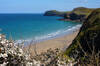
Lundy Bay is situated on the east side of The Rumps headland and consists of 3 small beaches. The leftmost two are sometimes known as Lundy Beach and between them there is a collapsed cave, forming an arch opening onto the beach. At high tide, the beaches are rocky, but at low tide, beautiful golden sand is revealed.
Due to the north-facing bay and steep cliffs, it's quite sheltered from a southwesterly wind. The result is that when there is a good size swell, there can be some quite clean surf here near low tide when the westerly-facing beaches are blown out. The beach slopes more steeply than many of the west-facing surf beaches, so rides tend to be short.
- Tide times
- Beach info
- Map
- Dogs: allowed all year
Walks visiting Lundy Bay
-
2.9 miles/4.7 km - Moderate
Port Quin to Lundy Bay

Port Quin to Lundy Bay
2.9 miles/4.7 km - Moderate
A circular walk from the fishing village of Port Quin to the golden sandy beaches of Epphaven Cove and Lundy Bay with spectacular coastal scenery, via the cliff-edge folly on Doyden Point built as a gambling den.
-
9.9 miles/15.9 km - Moderate-strenuous
Port Isaac to Polzeath (via bus)

Port Isaac to Polzeath (via bus)
9.9 miles/15.9 km - Moderate-strenuous
A one-way coastal walk, made circular via an initial bus journey, from Port Isaac to Polzeath along the Rollercoaster Path to Port Quin, the golden beaches of Lundy Bay via the Iron Age hillfort on the twin headland of The Rumps.


Download the iWalk Cornwall app and use the QR scanner within the app to find out more about any of the walks above.