
Polkerris beach
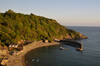
Polkerris is a fairly small crescent-shaped beach which is sandy at all states of the tide. It faces southwest into St Austell Bay - the quay was built to shelter the boats from the prevailing wind. This, together with its location on the corner of St Austell bay sheltering it from other wind directions makes it quite a good place to launch water craft. The gently sloping beach also adds to its popularity for swimming and water sports. On an exceptionally high tide, the sea can reach the wall of the old cellars, cutting off the area by the quay but nearly all the time the entire length of the beach is accessible. Beyond the quay is an area of rocks and to the other (right) end of the beach is another rock platform with rockpools at low tide.
Circular walks visiting Polkerris beach
-
3 miles/4.9 km - Moderate
Par Beach to Polkerris
Par Beach to Polkerris
3 miles/4.9 km - Moderate
A circular walk on the coast path and Saint's Way from Par to the fishing hamlet of Polkerris where the pub has retreated into the Lifeboat station after being washed away by a storm in Victorian times, and Napoleonic cannons were built into the harbour wall as mooring posts.
-
6.7 miles/10.8 km - Moderate-strenuous
Polkerris, Gribbin Head and Readymoney Cove

Polkerris, Gribbin Head and Readymoney Cove
6.7 miles/10.8 km - Moderate-strenuous
A circular walk near Fowey, from the tiny harbour of Polkerris, past the daymark tower on Gribbin Head and along the coast where Daphne du Maurier lived and based many of her books on, to the sandy beach at Readymoney Cove, returning on the Saint's Way.


Download the iWalk Cornwall app and use the QR scanner within the app to find out more about any of the walks above.