Circular walks around Morwenstow

Circular walks around Morwenstow

Morwenstow, Cornwall

Enjoy the walks by being guided by the app

Phone showing walk for purchase
Download the app and use it to explore the walks and to purchase a guided route.
Phone showing Google navigation to start of walk
The app will direct you to the start of the walk via satnav.
Hand holding a phone showing the iWalk Cornwall app
The app guides you around the walk using GPS, removing any worries about getting lost.
Phone showing walk directions page in the iWalk Cornwall app
The walk route is described with detailed, regularly-updated, hand-written directions.
Person looking a directions on phone
Each time there is a new direction to follow, the app will beep to remind you, and will warn you if you go off-route.
Phone showing walk map page in the iWalk Cornwall app
A map shows the route, where you are at all times and even which way you are facing.
Phone showing facts section in iWalk Cornwall app
Each walk is packed with information about the history and nature along the route, from over a decade of research than spans more than 3,000 topics.
Person looking at phone with cliff scenery in background
Once a walk is downloaded, the app doesn't need a phone or wifi signal during the walk.
Phone showing walk stats in the iWalk Cornwall app
The app counts down distance to the next direction and estimates time remaining based on your personal walking speed.
Person repairing footpath sign
We keep the directions continually updated for changes to the paths/landmarks - the price for a walk includes ongoing free updates.

Morwenstow is a collection of hamlets on the northeastern tip of Cornwall beside the Devon border. The high cliffs here have been cut into deep hanging valleys. The coastline is rugged and rocky although the accessible beaches are sandy at low tide. The area is famous for the eccentric opium-smoking Reverand Hawker including the National Trust's smallest property, nestled on a cliff edge.

  • 2.3 miles/3.7 km - Moderate-strenuous

    Morwenstow and Tidna Valley
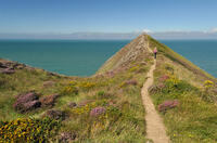
    Higher Sharpnose Point

    Morwenstow and Tidna Valley

    2.3 miles/3.7 km - Moderate-strenuous

    A short circular walk at Morwenstow to the cliff edge hut built from driftwood in which Reverend Hawker smoked opium and composed poetry, returning along the river valley to the ancient Bush Inn where medieval monks would rest the night before continuing their pilgrimage.

  • 3.8 miles/6.2 km - Moderate-strenuous

    Morwenstow to Stanbury Mouth

    Coastline at Morwenstow

    Morwenstow to Stanbury Mouth

    3.8 miles/6.2 km - Moderate-strenuous

    A circular walk from Morwenstow along the shipwreck coast to Stanbury Mouth where only nature's by-the-wind sailors now run aground

  • 4.4 miles/7 km - Strenuous

    Morwenstow to Marsland

    Marsland Mouth

    Morwenstow to Marsland

    4.4 miles/7 km - Strenuous

    A circular walk from Vicarage Cliff along the coast path to Marsland Mouth at the Devon border, returning through fields to Morwenstow rectory, church and the Rectory Tearooms - the last stand of the Cornish cream tea before the Devon border.

Download the iWalk Cornwall app and use the QR scanner within the app to find out more about any of the walks above.

Due to the deep valleys, the walks all include some reasonably steep climbs so are therefore relatively short routes to make up for this. The slightly longer two routes include a beach. The short Morwensow circular and the walk to Stanbury Mouth both end at the pub.