
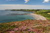
Walks in Cornwall with heather
Enjoy the walks by being guided by the app


-
3.4 miles/5.5 km - Easy
Botallack Head and Levant Mine

Botallack Head and Levant Mine
3.4 miles/5.5 km - Easy
A circular walk around Cornwall's most iconic mining remains, used for the filming of the BBC's Poldark series
-
6 miles/9.6 km - Easy
Twelveheads and Chacewater

Twelveheads and Chacewater
6 miles/9.6 km - Easy
A circular walk in the Copper Kingdom of the Old World where the majority of world's copper came from during the 18th and 19th Centuries
-
3.0 miles/4.9 km - Easy-moderate
St Agnes Beacon and Wheal Coates

St Agnes Beacon and Wheal Coates
3.0 miles/4.9 km - Easy-moderate
A circular walk between St Agnes Head and the engine houses of Wheal Coates via St Agnes Beacon, with spectacular panoramic views There are nice displays of heather flowers around Wheal Coates and along the coast from here towards St Agnes Head.
-
3.4 miles/5.4 km - Easy-moderate
Wheal Maid and Poldice Valley

Wheal Maid and Poldice Valley
3.4 miles/5.4 km - Easy-moderate
A circular walk in the area described in Victorian times as the richest square mile anywhere on Earth
-
3.9 miles/6.3 km - Easy-moderate
Land's End

Land's End
3.9 miles/6.3 km - Easy-moderate
A circular walk on the rugged cliffs at the most westerly point of the British mainland with spectacular views and spectacular wildflowers.
-
4.3 miles/7 km - Easy-moderate
Tehidy Woods to Deadman's Cove

Tehidy Woods to Deadman's Cove
4.3 miles/7 km - Easy-moderate
A circular walk through the wildlife reserve and bluebell woodland of Tehidy Country Park to Deadman's Cove and the North Cliffs, where many sailing ships were wrecked before the Godrevy Lighthouse was built.
-
4.7 miles/7.6 km - Easy-moderate
Deadman's Cove to Red River Valley

Deadman's Cove to Red River Valley
4.7 miles/7.6 km - Easy-moderate
A circular walk along a coast of shipwrecks and smugglers from Deadman's Cove to Hell's Mouth, past the collapse of the North Cliffs that went viral on YouTube, and returning through the nature reserve along the Red River Valley.
-
3.1 miles/4.9 km - Moderate
Trevaunance Cove and Blue Hills mine

Trevaunance Cove and Blue Hills mine
3.1 miles/4.9 km - Moderate
A circular walk along the stream of Trevellas Coombe where tin ore is still worked using traditional water power, past Stippy Stappy - the row of sea captain's cottages, and down the valley to the sandy beach of Trevaunance Cove with the remains of Victorian harbour which was demolished by Atlantic storms. There is a lot of heather around Trevellas Porth. The path crossing the headland from Trevaunce Cove often has nice displays of flowers.
-
3.2 miles/5.1 km - Moderate
Lizard to Kynance Cove (shorter version)

Lizard to Kynance Cove (shorter version)
3.2 miles/5.1 km - Moderate
A circular walk from Lizard village to Kynance Cove with spectacular views, wildflowers including Cornwall's county flower and wildlife including the Cornish Chough. There is lots of heather along the return route from Kynance Cove including Cornish Heath which is only found on The Lizard.
-
3.8 miles/6.1 km - Moderate
Porth Nanven to Nanquidno

Porth Nanven to Nanquidno
3.8 miles/6.1 km - Moderate
A circular walk from the Cot Valley past the beaches of Nanquidno and Porth Nanven where granite boulders polished over millions of years by prehistoric oceans and then buried by the soil are being exposed once again by the sea.
-
4.4 miles/7 km - Moderate
Kennack Sands to Lankidden Cove

Kennack Sands to Lankidden Cove
4.4 miles/7 km - Moderate
A circular walk on The Lizard from Kennack Sands where some of the oldest prehistoric finds have been made in Cornwall, including an entire lost Stone Age village which was uncovered by a gorse fire in the 1960s. Spectacular display of heather on the coast just after Kennack Sands
-
4.4 miles/7.1 km - Moderate
The Lizard and Kynance Cove

The Lizard and Kynance Cove
4.4 miles/7.1 km - Moderate
A circular walk along the Victorian Excursion route from Lizard village to the most southerly point and along the coast path to Kynance Cove with spectacular views, wildflowers, and wildlife including the Cornish Chough. There is lots of heather along the return route from Kynance Cove including Cornish Heath which is only found on The Lizard.
-
4.7 miles/7.5 km - Moderate
Perranporth to St Agnes (via bus)

Perranporth to St Agnes (via bus)
4.7 miles/7.5 km - Moderate
A one-way coastal walk, made circular via an initial bus journey, along the ore-bearing cliffs between Perranporth and St Agnes passing the remains of Nobel's dynamite works, Britain's best preserved spitfire base and the Blue Hills of Trevellas Coombe where tin is still processed on a small scale using traditional methods. There is heather along the coast path from Cligga Head to the airfield.
-
4.7 miles/7.5 km - Moderate
Porthtowan to Chapel Porth

Porthtowan to Chapel Porth
4.7 miles/7.5 km - Moderate
A circular walk from Porthtowan, along the coast, valleys and woodland, passing engine houses and other relics of Cornish copper mining.
-
4.8 miles/7.8 km - Moderate
Godolphin to Tregonning

Godolphin to Tregonning
4.8 miles/7.8 km - Moderate
A circular walk from the mansion with possibly the oldest formal gardens in the country to two hills that altered the course of history, creating the wealthiest estate in Cornwall and giving rise to the Cornish China Clay industry.
-
5.0 miles/8.1 km - Moderate
Hell's Mouth to Godrevy

Hell's Mouth to Godrevy
5.0 miles/8.1 km - Moderate
A circular walk following the coast from Hell's Mouth past Godrevy lighthouse to the sandy beaches of St Ives Bay, returning via a pilgrimage route along the Red River Valley.
-
5.1 miles/8.2 km - Moderate
Predannack to Kynance Cove

Predannack to Kynance Cove
5.1 miles/8.2 km - Moderate
A circular walk through the Lizard National Nature Reserve from Predannack to Kynance Cove along the rugged Serpentine cliffs where the "great silver ship" was wrecked in 1616 and more than 700 Spanish silver coins have so far been found. There is lots of heather along the return route including Cornish Heath which is only found on The Lizard.
-
5.3 miles/8.6 km - Moderate
Kit Hill to Kelly Bray

Kit Hill to Kelly Bray
5.3 miles/8.6 km - Moderate
A circular walk in Kit Hill Country Park, given to the county by the Duchy to mark the birth of Prince William and where a midsummer bonfire is lit to celebrate the ancient Celtic Golowan festival
-
5.4 miles/8.6 km - Moderate
Cape Cornwall to Levant

Cape Cornwall to Levant
5.4 miles/8.6 km - Moderate
A circular walk from England's only Cape, via the engine houses of Kenidjack Valley and perched on rock ledges at Botallack Head, to Levant Mine which had over 60 miles of tunnels beneath the Atlantic and now has a working restored beam engine.
-
5.7 miles/9.1 km - Moderate
Perranporth to Trevellas

Perranporth to Trevellas
5.7 miles/9.1 km - Moderate
A circular walk past the remains of Alfred Nobel's dynamite works to the red-and-yellow ore-rich cliffs above the wreck of the treasure ship Hanover, returning, via the spitfire base, along Perran Coombe where a 2-mile leat once carried water to power a massive waterwheel in a chamber within the cliffs. There is heather along the coast path from Cligga Head to the airfield.
-
5.9 miles/9.5 km - Moderate
Carn Brea and the Great Flat Lode

Carn Brea and the Great Flat Lode
5.9 miles/9.5 km - Moderate
A circular walk along the Great Flat Lode, where the Basset family made their fortune from the rich mineral reserves, to Carn Brea where they built a hunting lodge balanced on a tor in the style of a castle. There is lots of heather on Carn Brea, and the stretch after the Basset Monument is particularly colourful when in flower.
-
6 miles/9.7 km - Moderate
Sennen Cove, Land's End and Nanjizal

Sennen Cove, Land's End and Nanjizal
6 miles/9.7 km - Moderate
A circular walk from the white sandy beach at Sennen Cove along the towering granite cliffs via Land's End to the song of the sea cave at Nanjizal. The best way to see Land's End.
-
6.2 miles/10 km - Moderate
Chapel Porth to Trevaunance Cove

Chapel Porth to Trevaunance Cove
6.2 miles/10 km - Moderate
A circular walk along the coast between the golden sandy beaches of Chapel Porth and Trevaunance Cove at St Agnes via the iconic engine houses of Wheal Coates, perched above the breakers. There are nice displays of heather flowers around Wheal Coates and along the coast from here towards St Agnes Head.
-
7.1 miles/11.5 km - Moderate
Portheras Cove and Chûn Quoit

Portheras Cove and Chûn Quoit
7.1 miles/11.5 km - Moderate
A circular walk along the coast to the white, sandy beach of Portheras Cove and across the Penwith Moors to a prehistoric tomb the age of the Egyptian Pyramids
-
7.4 miles/11.8 km - Moderate
St Just to Nanquidno

St Just to Nanquidno
7.4 miles/11.8 km - Moderate
A circular walk from St Just to Cape Cornwall and the Cot Valley, where an ancient beach has been eroded from the cliffs at Porth Nanven, releasing granite boulders resembling Dinosaur eggs. There is a nice display of heather at Nanjulian.
-
2.3 miles/3.7 km - Moderate-strenuous
Morwenstow and Tidna Valley

Morwenstow and Tidna Valley
2.3 miles/3.7 km - Moderate-strenuous
A short circular walk at Morwenstow to the cliff edge hut built from driftwood in which Reverend Hawker smoked opium and composed poetry, returning along the river valley to the ancient Bush Inn where medieval monks would rest the night before continuing their pilgrimage. There is a nice display of heather around Higher Sharpnose Point.
-
2.9 miles/4.6 km - Moderate-strenuous
Crackington Haven to St Gennys Church

Crackington Haven to St Gennys Church
2.9 miles/4.6 km - Moderate-strenuous
A circular walk from the surf beach at Crackington Haven to the mediaeval church at St Gennys via the imposing Penkenna Point, where there are spectacular views of the bay and the secluded landing points used by some of North Cornwall's most notorious smugglers and wreckers. There is a spectacular display of heather at Castle Point.
-
3.8 miles/6.2 km - Moderate-strenuous
Morwenstow to Stanbury Mouth

Morwenstow to Stanbury Mouth
3.8 miles/6.2 km - Moderate-strenuous
A circular walk from Morwenstow along the shipwreck coast to Stanbury Mouth where only nature's by-the-wind sailors now run aground There is a nice display of heather around Higher Sharpnose Point.
-
4.2 miles/6.8 km - Moderate-strenuous
Rosemergy to Gurnard's Head

Rosemergy to Gurnard's Head
4.2 miles/6.8 km - Moderate-strenuous
A circular walk along the coast past the towering cliffs of Bosigran Castle via the white sand and huge boulders of Porthmeor Cove to the site of an Iron Age fort on Gurnard's Head, returning from the Gurnard's Head pub via the ancient Zennor Churchway. There are nice heather flowers on Gurnard's Head.
-
4.2 miles/6.7 km - Moderate-strenuous
Zennor to Gurnard's Head

Zennor to Gurnard's Head
4.2 miles/6.7 km - Moderate-strenuous
A circular walk from Zennor along the coast to the site of an Iron Age fort on Gurnard's Head, returning from the Gurnard's Head pub on the ancient Churchway to Zennor. There are nice heather flowers on Zennor Head and Gurnard's Head
-
4.3 miles/6.9 km - Moderate-strenuous
Crackington Haven to The Strangles

Crackington Haven to The Strangles
4.3 miles/6.9 km - Moderate-strenuous
A circular walk from Crackington Haven, with panoramic views of the Shipwreck Coast, to the long, sandy Strangles beach, returning through bluebell woodland along the Ludon river valley.
-
4.9 miles/7.8 km - Moderate-strenuous
The Strangles to Buckator

The Strangles to Buckator
4.9 miles/7.8 km - Moderate-strenuous
A circular walk along the volcanic coastline north of Boscastle, including Cornwall's highest cliff and The Strangles beach with its spectacular arch known as the Northern Door. There is heather along the coast path from The Strangles to High Cliff.
-
5.2 miles/8.4 km - Moderate-strenuous
Portreath and Tehidy Woods

Portreath and Tehidy Woods
5.2 miles/8.4 km - Moderate-strenuous
A circular walk along the rugged North Cliffs hiding smuggler's coves such as Ralph's Cupboard, to the sandy beach and historic mining port of Portreath, returning via the bluebell woodland of Illogan and Tehidy Country Park.
-
5.4 miles/8.6 km - Moderate-strenuous
Duckpool to Woodford

Duckpool to Woodford
5.4 miles/8.6 km - Moderate-strenuous
A circular walk in Morwenstow parish along towering cliffs and through broadleaf woods where a hamlet has been preserved in a joint project between the Landmark Trust and National Trust
-
5.4 miles/8.6 km - Moderate-strenuous
Zennor to The Carracks

Zennor to The Carracks
5.4 miles/8.6 km - Moderate-strenuous
A circular walk towards St Ives from Zennor following the Coast Path past the haunts of the legendary mermaid of Zennor to the islets of The Carracks, frequented by seals, and returning on the Coffin Path, along which villagers made their final journey to Zennor church. There is usually a nice display of heather flowers on Zennor Head.
-
5.5 miles/8.8 km - Moderate-strenuous
Carn Galver to Mên-an-Tol

Carn Galver to Mên-an-Tol
5.5 miles/8.8 km - Moderate-strenuous
A circular walk from the coast to the highest area of moor on West Penwith passing engine houses and prehistoric monuments and with spectacular heather in late summer There is lots of heather on the moor and the flowers are particularly vivid around the rock outcrops on Carn Galver.
-
7.3 miles/11.8 km - Moderate-strenuous
Coverack to Lankidden Cove

Coverack to Lankidden Cove
7.3 miles/11.8 km - Moderate-strenuous
A circular walk on one of the most remote parts of The Lizard from Coverack to the white sand beaches of Downas and Lankidden Coves, where the serpentine underwater landscape provides some of the best snorkelling in Cornwall.
-
7.7 miles/12.4 km - Moderate-strenuous
Zennor to St Ives (via bus)

Zennor to St Ives (via bus)
7.7 miles/12.4 km - Moderate-strenuous
A fairly demanding but rewarding one-way coastal walk, made circular via an initial bus journey, along the rugged coast between St Ives and Zennor, passing Seal Island which may have given rise to the legend of the mermaid of Zennor and - thanks to some imaginative naming - ice cream (Moomaid of Zennor). The walk is in the optimal direction to remove time pressure and for panoramic views across St Ives bay. There is usually a nice display of heather flowers on Zennor Head and Trevega Cliff.
-
12.1 miles/19.4 km - Moderate-strenuous
St Ives to Zennor

St Ives to Zennor
12.1 miles/19.4 km - Moderate-strenuous
A fairly long and demanding but rewarding circular walk along the coffin path and rugged coast between St Ives and Zennor. The walk is organised so that the coastal section is in the optimal direction for panoramic views across St Ives bay. There is usually a nice display of heather flowers on Zennor Head.
-
4.4 miles/7 km - Strenuous
Morwenstow to Marsland

Morwenstow to Marsland
4.4 miles/7 km - Strenuous
A circular walk from Vicarage Cliff along the coast path to Marsland Mouth at the Devon border, returning through fields to Morwenstow rectory, church and the Rectory Tearooms - the last stand of the Cornish cream tea before the Devon border.
-
4.5 miles/7.3 km - Strenuous
St Gennys Church to Dizzard

St Gennys Church to Dizzard
4.5 miles/7.3 km - Strenuous
A circular walk at St Gennys from the mediaeval church, via the smuggling routes though bluebell woods along the stream and an Iron Age clifftop fort crumbling into the sea, to some of North Cornwall's most remote coastline. There is a spectacular display of heather at Castle Point.
-
6.4 miles/10.3 km - Strenuous
Crackington Haven to Widemouth (via bus)

Crackington Haven to Widemouth (via bus)
6.4 miles/10.3 km - Strenuous
A one-way coastal walk, made circular via an initial bus journey, along the Shipwreck Coast from Crackington Haven to Widemouth Bay passing the bluebell woodland of ancient twisted oaks at The Dizzard, chevron folded rocks and honeycomb reefs of Millook Haven and fossil beds of Wanson Mouth. There is a spectacular display of heather at Castle Point.
-
7 miles/11.2 km - Strenuous
Crackington Haven to Boscastle (via bus)

Crackington Haven to Boscastle (via bus)
7 miles/11.2 km - Strenuous
A one-way coastal walk, made circular via an initial bus journey, along the Shipwreck Coast from Crackington Haven to Boscastle passing the highest cliff in Cornwall and the long, sandy beach at The Strangles. There is heather along the coast path from The Strangles to High Cliff.
-
7.3 miles/11.7 km - Strenuous
Portreath to Wheal Tye

Portreath to Wheal Tye
7.3 miles/11.7 km - Strenuous
A circular walk along the rugged coast from Portreath towards Porthtowan passing small coves and remnants of the clifftop mines beside the old RAF base, and returning via the horse-drawn tramway that brought fortune to Portreath harbour, where its "lighthouse" and "monkey house" remain from the shipping activity. There is extensive heather along the coastal side of Nancekuke Common.


Download the iWalk Cornwall app and use the QR scanner within the app to find out more about any of the walks above.
