
Walks in Cornwall less likely to have seasonally overgrown paths
Enjoy the walks by being guided by the app


These are walks less likely to be obstructed by vegetation whilst cutting teams are racing to catch up during June and July after the vegetation has bolted at the end of May.
-
2 miles/3.2 km - Easy
Trevose Head (short version)

Trevose Head (short version)
2 miles/3.2 km - Easy
A circular walk around the rugged coastline of Trevose Head via the iconic lighthouse and golden sandy beach at Mother Ivey's Bay, with spectacular wildflowers in spring and summer and thundering waves in winter that sometimes expose the shipwreck at Booby's Bay.
-
2.2 miles/3.6 km - Easy
Eden Project

Eden Project
2.2 miles/3.6 km - Easy
A walk though a granite landscape mined first for tin, then china clay and now for geothermal power to generate electricity and heat the space-age greenhouses of the Eden Project.
-
2.7 miles/4.3 km - Easy
Hayle and The Towans

Hayle and The Towans
2.7 miles/4.3 km - Easy
A circular walk on the Towans at Hayle, where Cornwall's beam engines were cast using sand from a prehistoric lagoon when West Penwith was an island.
-
3.2 miles/5.2 km - Easy
King's Wood and Pentewan Valley

King's Wood and Pentewan Valley
3.2 miles/5.2 km - Easy
A circular walk through the King's Wood Woodland Trust reserve to the lost port of Pentewan, along the trackbed of the horse-drawn tramway that once carried china clay to the busy port and via the system of reservoirs and sluices that were used to flush sand out of the harbour.
-
3.4 miles/5.5 km - Easy
Botallack Head and Levant Mine

Botallack Head and Levant Mine
3.4 miles/5.5 km - Easy
A circular walk around Cornwall's most iconic mining remains, used for the filming of the BBC's Poldark series
-
3.5 miles/5.6 km - Easy
Bude to Northcott Mouth

Bude to Northcott Mouth
3.5 miles/5.6 km - Easy
A circular walk past the historic Sea Pool to Crooklets beach and along Maer cliff to the beach at Northcott Mouth, where the shipwreck of the SS Belem is exposed at low tide.
-
3.5 miles/5.6 km - Easy
Par and Tywardreath

Par and Tywardreath
3.5 miles/5.6 km - Easy
A circular walk at Tywardreath where a mediaeval Priory was based and Par where much of the route was once a tidal creek and a wetland nature reserve has been created on some of the reclaimed land.
-
3.7 miles/6 km - Easy
Polzeath to St Enodoc Church

Polzeath to St Enodoc Church
3.7 miles/6 km - Easy
A circular walk along the coast from Polzeath past a number of small coves to the vast sandy beach at Daymer Bay, returning through the dunes past St Enodoc Church which was once so deeply buried in the sand that entrance for services was through the roof.
-
3.9 miles/6.3 km - Easy
Bude Canal and Coast

Bude Canal and Coast
3.9 miles/6.3 km - Easy
A figure-of-8 walk at Bude where the demand for lime-rich sand could not even be met by a reported 4000 horses a day, and so a 35-mile canal was built to transport it to the Tamar Valley.
-
4.1 miles/6.6 km - Easy
Constantine to Scott's Quay

Constantine to Scott's Quay
4.1 miles/6.6 km - Easy
A circular walk at Constantine through woods and to the creek on the Helford river where a bustling quarrying and mining industry operated in Victorian times but have now been reclaimed by nature.
-
4.4 miles/7.1 km - Easy
Truro and the old Newham railway

Truro and the old Newham railway
4.4 miles/7.1 km - Easy
A circular walk at Truro along the river, trackbed of the Newham railway and through the historic city centre.
-
5.9 miles/9.5 km - Easy
Goss Moor

Goss Moor
5.9 miles/9.5 km - Easy
A circular walk in the Goss Moor nature reserve which has reclaimed an industrial landscape which grew around Cornwall's largest alluvial tin deposits.
-
6 miles/9.7 km - Easy
Marazion to Penzance
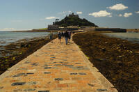
Marazion to Penzance
6 miles/9.7 km - Easy
A circular walk around Mount's Bay where the remains of the prehistoric forest that surrounded St Michael's Mount can still occasionally be seen on very low tides after storms
-
6 miles/9.6 km - Easy
Twelveheads and Chacewater

Twelveheads and Chacewater
6 miles/9.6 km - Easy
A circular walk in the Copper Kingdom of the Old World where the majority of world's copper came from during the 18th and 19th Centuries
-
2.2 miles/3.6 km - Easy-moderate
West Pentire and Polly Joke

West Pentire and Polly Joke
2.2 miles/3.6 km - Easy-moderate
A circular walk through the poppy fields of West Pentire to Polly Joke beach, returning over the headland to the pub that was a cowshed until the mid-20th Century.
-
2.4 miles/3.8 km - Easy-moderate
Gwithian and Upton Towans

Gwithian and Upton Towans
2.4 miles/3.8 km - Easy-moderate
A circular walk around the nature reserve in the sand dunes that was once the National Explosives Works where girls manufactured dynamite from nitroglycerine.
-
2.4 miles/3.9 km - Easy-moderate
Tintagel, Church and Castle

Tintagel, Church and Castle
2.4 miles/3.9 km - Easy-moderate
A short circular walk exploring some of the historic sites in Tintagel including Tintagel Castle and Merlin's Cave, the Old Post Office, and the ancient parish church on the cliffs.
-
2.5 miles/4 km - Easy-moderate
Bodmin town and beacon

Bodmin town and beacon
2.5 miles/4 km - Easy-moderate
A circular walk to the Beacon Local Nature Reserve, Jail and through Bodmin's historic centre.
-
3 miles/4.8 km - Easy-moderate
Looe woodland, river and coast

Looe woodland, river and coast
3 miles/4.8 km - Easy-moderate
A walk following the West Looe river from woods to its confluence and then to meet the Atlantic beside one of Cornwall's mediaeval ports.
-
3.0 miles/4.9 km - Easy-moderate
St Agnes Beacon and Wheal Coates

St Agnes Beacon and Wheal Coates
3.0 miles/4.9 km - Easy-moderate
A circular walk between St Agnes Head and the engine houses of Wheal Coates via St Agnes Beacon, with spectacular panoramic views
-
3 miles/4.8 km - Easy-moderate
Tintagel Church to Trebarwith Strand

Tintagel Church to Trebarwith Strand
3 miles/4.8 km - Easy-moderate
A circular walk on quarrymens' trails along the cliffs of Tintagel past the Thunderhole blowhole to the long, sandy beach at Trebarwith Strand from Tintagel's mediaeval clifftop church with relics including the font that once stood in Tintagel Castle's chapel.
-
3.1 miles/5 km - Easy-moderate
Padstow to Harbour Cove

Padstow to Harbour Cove
3.1 miles/5 km - Easy-moderate
A circular walk through Padstow's mediaeval network of streets to the church, the Elizabethan Manor at Prideaux Place and Tregirls Farm, with panoramic views of the estuary, returning along a mile of sandy beaches.
-
3.2 miles/5.1 km - Easy-moderate
Lanhydrock Gardens

Lanhydrock Gardens
3.2 miles/5.1 km - Easy-moderate
A fairly short and easy circular walk through Lanhydrock gardens with plenty of picnic spots along the River Fowey that you can combine with a visit to the house.
-
3.3 miles/5.3 km - Easy-moderate
Penrose to the Loe Bar

Penrose to the Loe Bar
3.3 miles/5.3 km - Easy-moderate
A circular walk alongside the Loe Pool to the Loe Bar and back via the farm on the hill spur, which in Cornish gave the name to the Penrose Estate.
-
3.3 miles/5.4 km - Easy-moderate
Towan Beach to Place House

Towan Beach to Place House
3.3 miles/5.4 km - Easy-moderate
A walk on contrasting coastlines, from the rugged Roseland coast to the sheltered creeks of the Percuil River opposite St Mawes.
-
3.4 miles/5.4 km - Easy-moderate
St Anthony Head (short version)

St Anthony Head (short version)
3.4 miles/5.4 km - Easy-moderate
A walk on the Roseland coast and then into the Fal estuary to St Anthony Church via the fort St Anthony Head and the golden sandy beaches of Molunan.
-
3.4 miles/5.4 km - Easy-moderate
Wheal Maid and Poldice Valley

Wheal Maid and Poldice Valley
3.4 miles/5.4 km - Easy-moderate
A circular walk in the area described in Victorian times as the richest square mile anywhere on Earth
-
3.6 miles/5.8 km - Easy-moderate
Lost Church and Perranporth dunes

Lost Church and Perranporth dunes
3.6 miles/5.8 km - Easy-moderate
A circular walk on the highest dune system in Britain to the chapel dating from Celtic times which was lost in the dunes for nearly 1000 years.
-
3.7 miles/6.0 km - Easy-moderate
Calstock

Calstock
3.7 miles/6.0 km - Easy-moderate
A walk at Calstock where a Victorian mineral railway from Kelly Bray once ran down to the quayside and the viaduct was built in the 1900s to connect this to Plymouth, creating today's Tamar Valley Line.
-
3.7 miles/5.9 km - Easy-moderate
Lerryn River and Tivoli lost gardens

Lerryn River and Tivoli lost gardens
3.7 miles/5.9 km - Easy-moderate
A woodland and riverside walk at Lerryn - thought to be the inspiration for the book The Wind In The Willows - and the lost pleasure gardens of Tivoli Park
-
3.8 miles/6.1 km - Easy-moderate
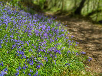
Lanhydrock to Respryn

Lanhydrock to Respryn
3.8 miles/6.1 km - Easy-moderate
A circular walk through the mature broadleaf woodland in the less well-known areas of the Lanhydrock estate, through bluebell woods and along the River Fowey, past the mediaeval bridge at Respryn, built after numerous prayers for safe passage in the ford-side chapel, had not resulted in the desired outcome.
-
3.9 miles/6.2 km - Easy-moderate
Holywell to Polly Joke

Holywell to Polly Joke
3.9 miles/6.2 km - Easy-moderate
A circular walk from Holywell Bay on the dunes and Kelsey Head to the sandy beach of Polly Joke.
-
3.9 miles/6.3 km - Easy-moderate
Land's End

Land's End
3.9 miles/6.3 km - Easy-moderate
A circular walk on the rugged cliffs at the most westerly point of the British mainland with spectacular views and spectacular wildflowers.
-
3.9 miles/6.3 km - Easy-moderate
Penzance to Newlyn

Penzance to Newlyn
3.9 miles/6.3 km - Easy-moderate
A circular walk at Mount's Bay from the largest port town in the bay to the harbour of Cornwall's largest fishing fleet.
-
3.9 miles/6.2 km - Easy-moderate
Stannon Moor prehistoric relics

Stannon Moor prehistoric relics
3.9 miles/6.2 km - Easy-moderate
A circular walk around Stannon Moor near St Breward with panoramic views of Bodmin Moor, passing stone circles, burial chambers and other prehistoric monuments to a massive granite boulder balanced on Louden Hill which gently rocks if you sit on it.
-
4 miles/6.5 km - Easy-moderate
Mylor and Restronguet Creeks

Mylor and Restronguet Creeks
4 miles/6.5 km - Easy-moderate
A circular walk along the Mylor and Restronguet creeks via the Pandora Inn, said to be once owned and renamed by the captain of HMS Pandora sent to capture mutineers from The Bounty, and where a passing-boat was kept to connect the post road between Falmouth and Truro, summoned by a bell on the other side of the creek.
-
4 miles/6.4 km - Easy-moderate
Watergate Bay to Newquay (via bus)

Watergate Bay to Newquay (via bus)
4 miles/6.4 km - Easy-moderate
A one-way coastal walk, made circular via an initial bus journey, from Watergate Bay along the coast path to Newquay, passing the sea caves at Whipsiderry beach, the Iron Age hillfort on Trevelgue head and the beaches of Porth, Lusty Glaze and Tolcarne.
-
4.5 miles/7.2 km - Easy-moderate
Cardinham Woods and Lady Vale
Cardinham Woods and Lady Vale
4.5 miles/7.2 km - Easy-moderate
A circular walk in the wooded valley surrounding Cardinham Water where the mediaeval chapel of St Mary de Valle once stood but now only the Lady Vale mediaeval bridge remains.
-
4.7 miles/7.6 km - Easy-moderate
Trelissick

Trelissick
4.7 miles/7.6 km - Easy-moderate
A figure-of-8 walk along the creeks of the River Fal through the 300 acre estate surrounding Trelissick House.
-
4.8 miles/7.7 km - Easy-moderate
Saltash and the Lynher Valley

Saltash and the Lynher Valley
4.8 miles/7.7 km - Easy-moderate
A circular walk in the ferry town that was the main riverside settlement in mediaeval times when Plymouth was moorland, and where a handful of Elizabethan buildings still remain from the period when Francis Drake built a property empire from his circumnavigation of the globe.
-
4.9 miles/7.9 km - Easy-moderate
Holywell to Crantock

Holywell to Crantock
4.9 miles/7.9 km - Easy-moderate
A circular walk from Holywell Bay past the remarkable sacred spring and along the coast to the sandy beaches of Porth Joke and Crantock, returning via the dunes of the Cubert Common nature conservation area.
-
5 miles/8 km - Easy-moderate
St Austell, Clay Trails and Menacuddle Well

St Austell, Clay Trails and Menacuddle Well
5 miles/8 km - Easy-moderate
A circular walk in china clay country, including a trail laid on the trackbed of a mineral railway from St Austell to the Cornish Alps and one of Cornwall's most picturesque holy wells.
-
5.4 miles/8.7 km - Easy-moderate
Falmouth and Pendennis Point

Falmouth and Pendennis Point
5.4 miles/8.7 km - Easy-moderate
A circular walk around the thriving town of Falmouth, which didn't exist until Elizabethan times when Sir Walter Raleigh suggested that the largest natural harbour in Europe would be a good place to build a port town.
-
5.8 miles/9.4 km - Easy-moderate
Rock to Polzeath

Rock to Polzeath
5.8 miles/9.4 km - Easy-moderate
A circular walk across the dunes and headland between Rock and Polzeath, returning via St Enodoc Church, where Sir John Betjeman is buried.
-
5.9 miles/9.5 km - Easy-moderate
St Anthony Head

St Anthony Head
5.9 miles/9.5 km - Easy-moderate
A walk along the Roseland coast and creeks opposite St Mawes, passing the preserved fort and Fraggle Rock lighthouse on St Anthony Head and the golden sandy beaches of Molunan.
-
6 miles/9.6 km - Easy-moderate
Penrose and Porthleven

Penrose and Porthleven
6 miles/9.6 km - Easy-moderate
A circular walk through the woodland alongside the Loe to the most southerly port on the British mainland, famous for its huge storm waves.
-
6.1 miles/9.8 km - Easy-moderate
Feock to Devoran

Feock to Devoran
6.1 miles/9.8 km - Easy-moderate
A circular walk to the Victorian-engineered town of Devoran which was once the largest mining port in Cornwall, and along Restronguet Creek on the route of the railway that lead from the ore bins and smelting houses to the mines of Redruth
-
6.4 miles/10.3 km - Easy-moderate
Daymer Bay to Padstow

Daymer Bay to Padstow
6.4 miles/10.3 km - Easy-moderate
A figure-of-8 walk from Daymer Bay through the dunes to Rock, passing the once-buried St Enodoc church, before crossing on the ferry to Padstow, and returning along three miles of sandy beaches.
-
6.6 miles/10.6 km - Easy-moderate
The Loe

The Loe
6.6 miles/10.6 km - Easy-moderate
A circular walk around the Loe Pool, the largest natural freshwater lake in Cornwall, and along the Loe Bar, one of Cornwall's most treacherous beaches on which 100 of those onboard the HMS Anson drowned metres from the shore, motivating the invention of the rocket lifesaving apparatus that saved thousands of lives.
-
6.8 miles/10.9 km - Easy-moderate
Seven Bays (via bus)

Seven Bays (via bus)
6.8 miles/10.9 km - Easy-moderate
A one-way coastal walk, made circular via an initial bus journey, along the Seven Bays coast and around Trevose Head past the lighthouse.
-
2.5 miles/4 km - Moderate
Danescombe Valley

Danescombe Valley
2.5 miles/4 km - Moderate
A circular walk from Cotehele Quay into the broadleaf woodland of the Danescombe Valley where bluebells and orchids flower in spring and fungi erupt through the carpet of autumn leaves.
-
2.7 miles/4.4 km - Moderate
Tintagel to Bossiney

Tintagel to Bossiney
2.7 miles/4.4 km - Moderate
A circular walk via through Tintagel to Tintagel Castle and along the coastline via the headlands of Barras Nose and Willapark to the sandy beach at Bossiney Haven from Tintagel Haven where Merlin's Cave is uncovered at low tide.
-
2.9 miles/4.7 km - Moderate
Charlestown to Porthpean

Charlestown to Porthpean
2.9 miles/4.7 km - Moderate
A circular walk between the sheltered cove at Porthpean and the historic port of Charlestown, originally built to export copper, then China Clay, and now used for filming by Hollywood and Poldark.
-
2.9 miles/4.7 km - Moderate
Polperro harbour and headlands

Polperro harbour and headlands
2.9 miles/4.7 km - Moderate
A figure-of-eight walk around the fishing village and headlands surrounding Polperro, passing the net loft perched above the harbour, the Victorian sea pool, the site of the mediaeval chapel and the harbourmaster's route to the lighthouse.
-
3.1 miles/4.9 km - Moderate
Kilminorth Woods and the Giant's Hedge

Kilminorth Woods and the Giant's Hedge
3.1 miles/4.9 km - Moderate
A woodland walk alongside the West Looe River where the Giant's Hedge once divided kingdoms of the Dark Ages, centuries before the ancient trees that now tower above it were even seedlings.
-
3.5 miles/5.6 km - Moderate
Padstow town and obelisk

Padstow town and obelisk
3.5 miles/5.6 km - Moderate
A short circular walk from Padstow harbour to the viewpoints at the War Memorial and Victorian obelisk, the Elizabethan Manor at Prideaux Place, and including some pretty backstreets that lie off the main tourist routes.
-
3.5 miles/5.7 km - Moderate
West Pentire to Crantock Beach

West Pentire to Crantock Beach
3.5 miles/5.7 km - Moderate
A circular walk on the northernmost end of one of Cornwall's largest areas of sand dunes that stretch from Crantock to Perranporth, under which one mediaeval chapel was found and another is said to still be lost.
-
3.8 miles/6.1 km - Moderate
Tintagel to Rocky Valley

Tintagel to Rocky Valley
3.8 miles/6.1 km - Moderate
A circular walk via King Arthur's Great Halls and the Old Post Office and along the coastline from Tintagel Castle past towering headlands and island bird colonies to the golden, sandy cove at Bossiney Haven, returning via the labyrinthine carvings and ruins of mills in the woods of Rocky Valley.
-
4 miles/6.5 km - Moderate
Bowithick to Buttern Hill

Bowithick to Buttern Hill
4 miles/6.5 km - Moderate
A circular walk over the northern tip of Bodmin Moor to the prehistoric burial chamber at the top of Buttern Hill and source of the River Fowey, returning via farm tracks and country lanes to the tributary streams of the River Inny.
-
4.3 miles/7 km - Moderate
St Ives

St Ives
4.3 miles/7 km - Moderate
A circular walk at St Ives along the granite coastline and white sandy beaches which have inspired so many artists, through some of the most famous parts of the town including the harbour, The Island and The Tate, and via the church and holy well of the Celtic girl Ia who, according to legend, was the first to settle here.
-
4.7 miles/7.5 km - Moderate
Perranporth to St Agnes (via bus)

Perranporth to St Agnes (via bus)
4.7 miles/7.5 km - Moderate
A one-way coastal walk, made circular via an initial bus journey, along the ore-bearing cliffs between Perranporth and St Agnes passing the remains of Nobel's dynamite works, Britain's best preserved spitfire base and the Blue Hills of Trevellas Coombe where tin is still processed on a small scale using traditional methods.
-
5.8 miles/9.3 km - Moderate
Newquay

Newquay
5.8 miles/9.3 km - Moderate
A circular walk around the UK's surf capital which was transformed from a tiny fishing village with a few thatched cottages when, in order to export ore from the harbour, a horse-drawn tramway was built across Cornwall which later became part of the Great Western Railway.
-
5.9 miles/9.5 km - Moderate
Cotehele to Calstock

Cotehele to Calstock
5.9 miles/9.5 km - Moderate
A circular walk through the gardens of Cotehele to Calstock where Cornwall's largest Roman fort once stood, the Vikings allied with the Cornish to fight off the Saxons, and more recently railway wagons were lifted over 100ft by steam power from the quay to the top of the viaduct.
-
6.9 miles/11.2 km - Moderate
Holywell Bay to Newquay (via bus)

Holywell Bay to Newquay (via bus)
6.9 miles/11.2 km - Moderate
A one-way coastal walk, made circular via an initial bus journey, from Holywell Bay along the coast and Gannel estuary to Newquay, passing the beaches of Porth Joke and Crantock and the headland of West Pentire where there is a spectacular display of red-and-gold wildflowers in June.
-
7.4 miles/12.1 km - Moderate
Trevone to Padstow

Trevone to Padstow
7.4 miles/12.1 km - Moderate
A circular walk to Padstow from Trevone beach, which tracks the route taken by sailing ships along the rugged Atlantic coast to the daymark at Stepper Point, past the infamous Doom Bar and the sandbanks of Hawker's, Harbour and St George's coves before finally reaching safe harbour in Padstow.
-
3.8 miles/6.1 km - Moderate-strenuous
Hall Walk from Fowey to Polruan

Hall Walk from Fowey to Polruan
3.8 miles/6.1 km - Moderate-strenuous
A circular version of the famous Hall Walk from Bodinnick to Polruan, recorded as a walk with "sweete senting flowers" in Tudor times and during the Civil War where a gun shot aimed at Charles I is said to have instead killed a fisherman who stood on the same spot moments later.
-
5.2 miles/8.4 km - Moderate-strenuous
Portreath and Tehidy Woods

Portreath and Tehidy Woods
5.2 miles/8.4 km - Moderate-strenuous
A circular walk along the rugged North Cliffs hiding smuggler's coves such as Ralph's Cupboard, to the sandy beach and historic mining port of Portreath, returning via the bluebell woodland of Illogan and Tehidy Country Park.
-
5.2 miles/8.4 km - Moderate-strenuous
Rough Tor and Brown Willy

Rough Tor and Brown Willy
5.2 miles/8.4 km - Moderate-strenuous
A mostly circular walk to Cornwall's two highest tors, passing prehistoric remains including the holy well, summit cairns and settlements.
-
6.8 miles/11.0 km - Moderate-strenuous
Porthcothan, Bedruthan Steps and Watergate Bay (via bus)
Porthcothan, Bedruthan Steps and Watergate Bay (via bus)
6.8 miles/11.0 km - Moderate-strenuous
A (bus-assisted) one-way walk along the coast with spectacular wildflowers and one of Cornwall's most photographed views over the volcanic rock stacks of Bedruthan Steps, which Victorians liked to think of as a giant's stepping stones.
-
7.7 miles/12.4 km - Moderate-strenuous
Zennor to St Ives (via bus)

Zennor to St Ives (via bus)
7.7 miles/12.4 km - Moderate-strenuous
A fairly demanding but rewarding one-way coastal walk, made circular via an initial bus journey, along the rugged coast between St Ives and Zennor, passing Seal Island which may have given rise to the legend of the mermaid of Zennor and - thanks to some imaginative naming - ice cream (Moomaid of Zennor). The walk is in the optimal direction to remove time pressure and for panoramic views across St Ives bay.
-
7.3 miles/11.7 km - Strenuous
Portreath to Wheal Tye

Portreath to Wheal Tye
7.3 miles/11.7 km - Strenuous
A circular walk along the rugged coast from Portreath towards Porthtowan passing small coves and remnants of the clifftop mines beside the old RAF base, and returning via the horse-drawn tramway that brought fortune to Portreath harbour, where its "lighthouse" and "monkey house" remain from the shipping activity.


Download the iWalk Cornwall app and use the QR scanner within the app to find out more about any of the walks above.
