
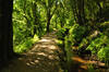
Walks in Cornwall with a good degree of shade
Enjoy the walks by being guided by the app


A substantial amount of the route for these walks is shaded by trees making them ideal for a leisurely cool stroll to avoid the direct sun during a heatwave.
-
1.8 miles/2.9 km - Easy
The Camelford Way

The Camelford Way
1.8 miles/2.9 km - Easy
A short and easy circular walk from Camelford along the wildflower-rich meadows of the River Camel to the clapper bridge at Fenteroon, returning through the fields with views over the Camel Valley.
-
3.2 miles/5.2 km - Easy
King's Wood and Pentewan Valley

King's Wood and Pentewan Valley
3.2 miles/5.2 km - Easy
A circular walk through the King's Wood Woodland Trust reserve to the lost port of Pentewan, along the trackbed of the horse-drawn tramway that once carried china clay to the busy port and via the system of reservoirs and sluices that were used to flush sand out of the harbour.
-
5.3 miles/8.5 km - Easy
Dunmere to Grogley Halt

Dunmere to Grogley Halt
5.3 miles/8.5 km - Easy
A circular walk along the Camel valley from Dunmere Halt to Grogley Halt on the Camel Trail, passing the Camel Valley vineyard and the Boscarne platform where the Bodmin-Wenford steam trains depart.
-
3.2 miles/5.1 km - Easy-moderate
Lanhydrock Gardens

Lanhydrock Gardens
3.2 miles/5.1 km - Easy-moderate
A fairly short and easy circular walk through Lanhydrock gardens with plenty of picnic spots along the River Fowey that you can combine with a visit to the house.
-
3.3 miles/5.2 km - Easy-moderate
St Keverne to Porthallow

St Keverne to Porthallow
3.3 miles/5.2 km - Easy-moderate
A circular walk through woods and meadows to Porthoustock and Porthallow from St Keverne, settled in the Dark Ages by Celtic monks trading with Brittany
-
3.4 miles/5.5 km - Easy-moderate
Luxulyan Valley circular

Luxulyan Valley circular
3.4 miles/5.5 km - Easy-moderate
A circular walk following the leats and horse-drawn tramways through the World Heritage site of the Luxulyan Valley to the massive viaduct which carried the tramways towards Newquay and water to winch the trams up the valley with a huge waterwheel, recommended in guidebooks as early as the 1920s "as one of the most glorious walks in all Cornwall".
-
3.7 miles/5.9 km - Easy-moderate
Lerryn River and Tivoli lost gardens

Lerryn River and Tivoli lost gardens
3.7 miles/5.9 km - Easy-moderate
A woodland and riverside walk at Lerryn - thought to be the inspiration for the book The Wind In The Willows - and the lost pleasure gardens of Tivoli Park
-
3.8 miles/6.1 km - Easy-moderate
Lanhydrock to Respryn

Lanhydrock to Respryn
3.8 miles/6.1 km - Easy-moderate
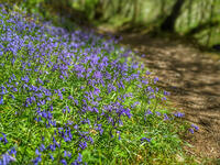
A circular walk through the mature broadleaf woodland in the less well-known areas of the Lanhydrock estate, through bluebell woods and along the River Fowey, past the mediaeval bridge at Respryn, built after numerous prayers for safe passage in the ford-side chapel, had not resulted in the desired outcome.
-
3.8 miles/6.1 km - Easy-moderate
St Clement and Malpas

St Clement and Malpas
3.8 miles/6.1 km - Easy-moderate
A circular walk at the confluence of the Truro and Tresillian rivers, once defended by Moresk castle and later where timber for the mines was unloaded and floated as rafts into Truro
-
4.1 miles/6.6 km - Easy-moderate
Degibna and Carminowe Valley

Degibna and Carminowe Valley
4.1 miles/6.6 km - Easy-moderate
A circular walk in the wooded valleys beside the Loe Pool with panoramic views over the lake
-
4.3 miles/7 km - Easy-moderate
Tehidy Woods to Deadman's Cove

Tehidy Woods to Deadman's Cove
4.3 miles/7 km - Easy-moderate
A circular walk through the wildlife reserve and bluebell woodland of Tehidy Country Park to Deadman's Cove and the North Cliffs, where many sailing ships were wrecked before the Godrevy Lighthouse was built.
-
4.4 miles/7 km - Easy-moderate
Giant's Quoit and Pendarves Wood

Giant's Quoit and Pendarves Wood
4.4 miles/7 km - Easy-moderate
A walk from a tiny village designed by Victorians, through ancient woodland that was once part of the Pendarves Estate to the prehistoric tomb that, despite two collapses over the centuries, is once again standing.
-
4.5 miles/7.2 km - Easy-moderate
Cardinham Woods and Lady Vale
Cardinham Woods and Lady Vale
4.5 miles/7.2 km - Easy-moderate
A circular walk in the wooded valley surrounding Cardinham Water where the mediaeval chapel of St Mary de Valle once stood but now only the Lady Vale mediaeval bridge remains.
-
4.7 miles/7.6 km - Easy-moderate
Trelissick

Trelissick
4.7 miles/7.6 km - Easy-moderate
A figure-of-8 walk along the creeks of the River Fal through the 300 acre estate surrounding Trelissick House.
-
5.1 miles/8.3 km - Easy-moderate
Deerpark to Herodsfoot

Deerpark to Herodsfoot
5.1 miles/8.3 km - Easy-moderate
A woodland walk in what's likely to have been a mediaeval deer park to the site of Cornwall's second-largest gunpowder manufacturing operation, which despite exploding several times was sufficiently successful to give rise to a nearby sister site known as Trago Mills.
-
6.2 miles/10 km - Easy-moderate
The Loe

The Loe
6.2 miles/10 km - Easy-moderate
A circular walk around the Loe Pool, the largest natural freshwater lake in Cornwall, and along the Loe Bar, one of Cornwall's most treacherous beaches on which 100 of those onboard the HMS Anson drowned metres from the shore, motivating the invention of the rocket lifesaving apparatus that saved thousands of lives.
-
6.5 miles/10.5 km - Easy-moderate
Budock Water and the Lakes

Budock Water and the Lakes
6.5 miles/10.5 km - Easy-moderate
A walk from what was once the parish church for Falmouth to the lakes in a river valley which the Celtic people described as secluded and where Argal Mill is thought to lie somewhere beneath the water in a Cornish version of Atlantis.
-
6.6 miles/10.7 km - Easy-moderate
St Mawgan to St Columb Major

St Mawgan to St Columb Major
6.6 miles/10.7 km - Easy-moderate
A circular walk along the Vale of Lanherne to the mediaeval market town of St Columb Major, where Cornish Hurling is still played, through the broadleaf woodland of the Carnanton Estate along the River Menalhyl, returning to the riverside pub, church and convent at St Mawgan.
-
6.7 miles/10.8 km - Easy-moderate
Penryn Creeks and Enys

Penryn Creeks and Enys
6.7 miles/10.8 km - Easy-moderate
A circular walk along the creeks of Carrick Roads and through the woodland of the Enys Estate, famous for its bluebells in spring
-
2.5 miles/4 km - Moderate
Danescombe Valley

Danescombe Valley
2.5 miles/4 km - Moderate
A circular walk from Cotehele Quay into the broadleaf woodland of the Danescombe Valley where bluebells and orchids flower in spring and fungi erupt through the carpet of autumn leaves.
-
2.6 miles/4.2 km - Moderate
Boscastle to Minster Church

Boscastle to Minster Church
2.6 miles/4.2 km - Moderate
A short circular walk from Boscastle through bluebell woodland alongside the River Valency to the ancient Celtic churchyard and sacred spring at Minster, returning along the River Jordan, beside which Bottreaux Castle was once situated, and Boscastle's Old Road.
-
3.1 miles/5.0 km - Moderate
St Breward to Lank

St Breward to Lank
3.1 miles/5.0 km - Moderate
A short circular walk from St Breward through ancient bluebell woods along the valley of the River Camel to the holy well, ending at the mediaeval church and inn.
-
3.5 miles/5.6 km - Moderate
Helman Tor and Red Moor

Helman Tor and Red Moor
3.5 miles/5.6 km - Moderate
A circular walk to the neolithic enclosure on the summit of Helman Tor and through the woodland of Cornwall's largest nature reserve.
-
3.6 miles/5.7 km - Moderate
Withiel and Tremore Valley

Withiel and Tremore Valley
3.6 miles/5.7 km - Moderate
A circular walk in the Ruthern and Tremore river valleys following the Saint's Way to Withiel where the award-winning cheese Cornish Yarg was first made from a recipe in a dusty book found in the attic, that is thought to date back to the 13th Century.
-
4.2 miles/6.8 km - Moderate
St Dominic to Cotehele Bridge

St Dominic to Cotehele Bridge
4.2 miles/6.8 km - Moderate
A figure-of-eight walk from St Dominic along the wooded valley to the quays of Bohetherick and Cotehele, where limestone and coal were continuously fed into kilns to produce lime for the market gardens in the Tamar Valley.
-
4.3 miles/6.9 km - Moderate
Treslea Downs and Warleggan

Treslea Downs and Warleggan
4.3 miles/6.9 km - Moderate
A circular walk at one of Cornwall's more remote and eccentric hamlets, displaying a "twinned with Narnia" sign and with a church where the vicar surrounded his rectory with barbed wire and preached to an empty church containing name cards of his parishioners
-
4.8 miles/7.8 km - Moderate
Luxulyan Valley to Prideaux

Luxulyan Valley to Prideaux
4.8 miles/7.8 km - Moderate
A circular walk through the World Heritage site of the Luxulyan Valley and surrounding countryside, over the massive viaduct supporting a horse-drawn tram route to Newquay and along the leat that fed Charlestown Harbour.
-
4.9 miles/7.8 km - Moderate
Ladock Woods and Holy Well

Ladock Woods and Holy Well
4.9 miles/7.8 km - Moderate
A circular walk from the woodland of The Duchy to the Holy Well of St Ladock in the river valley where in 1802 a gold nugget was found that contained enough gold to make an elegant necklace which is now in Truro museum.
-
5.1 miles/8.2 km - Moderate
Lerryn to St Winnow

Lerryn to St Winnow
5.1 miles/8.2 km - Moderate
A circular walk to the creekside church of St Winnow along the River Fowey and Lerryn where hoards of Roman coins have been found on the river banks, and overlooked by the manor house that is thought may have been the inspiration for Toad Hall in The Wind in the Willows.
-
5.2 miles/8.4 km - Moderate
Bodmin and Bodiniel - the two manors

Bodmin and Bodiniel - the two manors
5.2 miles/8.4 km - Moderate
A figure-of-8 walk through Bodmin's historic centre to the beacon nature reserve and through the woods at Dunmere to Scarlett's Well
-
5.9 miles/9.5 km - Moderate
Cotehele to Calstock

Cotehele to Calstock
5.9 miles/9.5 km - Moderate
A circular walk through the gardens of Cotehele to Calstock where Cornwall's largest Roman fort once stood, the Vikings allied with the Cornish to fight off the Saxons, and more recently railway wagons were lifted over 100ft by steam power from the quay to the top of the viaduct.
-
6.5 miles/10.5 km - Moderate
Duloe to Herodsfoot

Duloe to Herodsfoot
6.5 miles/10.5 km - Moderate
A circular walk through the woodland along the West Looe River to Herodsfoot from Duloe, where Cornwall's smallest stone circle stands.
-
3.8 miles/6.1 km - Moderate-strenuous
Hall Walk from Fowey to Polruan

Hall Walk from Fowey to Polruan
3.8 miles/6.1 km - Moderate-strenuous
A circular version of the famous Hall Walk from Bodinnick to Polruan, recorded as a walk with "sweete senting flowers" in Tudor times and during the Civil War where a gun shot aimed at Charles I is said to have instead killed a fisherman who stood on the same spot moments later.
-
4.5 miles/7.2 km - Moderate-strenuous
Gunnislake to Chilsworthy

Gunnislake to Chilsworthy
4.5 miles/7.2 km - Moderate-strenuous
A circular walk in the Tamar Valley at Gunnislake where Victorian canal systems, engine houses and tramways have been recolonised by nature and kingfishers rather than barges now journey up and down the river.


Download the iWalk Cornwall app and use the QR scanner within the app to find out more about any of the walks above.
