Whitsand Bay
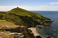
Whitsand Bay (without an "e" and extending from Rame Head) shouldn't be confused with Whitesand Bay (with an "e" and at Sennen Cove) despite the origin of both names being the same.
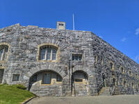
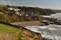
At high tide, there are several small beaches along Whitsand Bay, with Tregantle beach being the largest (but restricted when the firing ranges in the fort above are active - indicated by red flags). At low tide, the beaches join into a three mile strip of sand.
- Tide times
- Beach info
- Map
- Dogs: allowed all year
Circular walks visiting Whitsand Bay
-
5.2 miles/8.3 km - Easy-moderate
Tregantle to Crafthole

Tregantle to Crafthole
5.2 miles/8.3 km - Easy-moderate
A circular walk in tributary valleys of the St Germans River and past the Victorian coastal defences overlooking Whitsand Bay, where one of the forts is still in use today.
-
5.6 miles/9.0 km - Moderate
Rame Head and Cawsand

Rame Head and Cawsand
5.6 miles/9.0 km - Moderate
A circular walk around Rame Head - the southeastern corner of Cornwall - past the mediaeval chapel and the remains of a huge gun battery, now a nature reserve, on Penlee Point to Cawsand which was once the smuggling capital of Cornwall.
-
6.7 miles/10.8 km - Moderate-strenuous
Portwrinkle to Downderry

Portwrinkle to Downderry
6.7 miles/10.8 km - Moderate-strenuous
A circular walk around Whitsand Bay to Downderry from Portwrinkle, where the ghost of Silas Finn is said to haunt the cliffs.
Download the iWalk Cornwall app and use the QR scanner within the app to find out more about any of the walks above.

