
Walks in Cornwall visiting English Heritage sites
Enjoy the walks by being guided by the app


-
2.4 miles/3.9 km - Easy-moderate
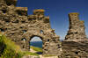
Tintagel, Church and Castle

Tintagel, Church and Castle
2.4 miles/3.9 km - Easy-moderate
A short circular walk exploring some of the historic sites in Tintagel including Tintagel Castle and Merlin's Cave, the Old Post Office, and the ancient parish church on the cliffs.
-
5.3 miles/8.5 km - Easy-moderate
Lanhydrock to Restormel

Lanhydrock to Restormel
5.3 miles/8.5 km - Easy-moderate
A circular walk from the mediaeval bridge at Respryn along the River Fowey through the bluebell woodland of the Lanhydrock Estate to the circular Norman castle at Restormel which had a pressurised piped water system 700 years ahead of its time.
-
5.4 miles/8.7 km - Easy-moderate
Falmouth and Pendennis Point

Falmouth and Pendennis Point
5.4 miles/8.7 km - Easy-moderate
A circular walk around the thriving town of Falmouth, which didn't exist until Elizabethan times when Sir Walter Raleigh suggested that the largest natural harbour in Europe would be a good place to build a port town. The route passes Pendennis Castle.
-
2.7 miles/4.4 km - Moderate
Tintagel to Bossiney

Tintagel to Bossiney
2.7 miles/4.4 km - Moderate
A circular walk via through Tintagel to Tintagel Castle and along the coastline via the headlands of Barras Nose and Willapark to the sandy beach at Bossiney Haven from Tintagel Haven where Merlin's Cave is uncovered at low tide.
-
3.3 miles/5.3 km - Moderate
Readymoney Cove to Polridmouth

Readymoney Cove to Polridmouth
3.3 miles/5.3 km - Moderate
A circular walk in du Maurier country from Readymoney Cove - where she lived in the 1940s - to Polridmouth, where the shipwreck inspired her book Rebecca. The route passes St Catherine's Castle.
-
3.8 miles/6.1 km - Moderate
Tintagel to Rocky Valley

Tintagel to Rocky Valley
3.8 miles/6.1 km - Moderate
A circular walk via King Arthur's Great Halls and the Old Post Office and along the coastline from Tintagel Castle past towering headlands and island bird colonies to the golden, sandy cove at Bossiney Haven, returning via the labyrinthine carvings and ruins of mills in the woods of Rocky Valley.
-
4.7 miles/7.6 km - Moderate
Fowey to Polridmouth

Fowey to Polridmouth
4.7 miles/7.6 km - Moderate
A figure-of-eight walk from Readymoney Cove past the Tudor fort and along the coast where Daphne du Maurier lived to Polridmouth, where the shipwreck inspired the end of her book Rebecca, and then along the mediaeval streets of Fowey. The route passes St Catherine's Castle.
-
5 miles/8 km - Moderate
Trebarwith Strand to Tintagel Castle

Trebarwith Strand to Tintagel Castle
5 miles/8 km - Moderate
A walk on the tracks trodden by the donkeys laden with slate from the coastal quarries of Trebarwith to Tintagel Haven where the slate was loaded onto ships and Tintagel Castle's island, inhabited during the mediaeval period, the Celtic times of King Arthur, and before this by the Romans.
-
5.5 miles/8.7 km - Moderate
Boscastle to Tintagel (via bus)

Boscastle to Tintagel (via bus)
5.5 miles/8.7 km - Moderate
A one-way coastal walk, made circular via an initial bus journey, along the dramatic coastline of islands and arches from Boscastle to Tintagel, rated as one of the top five walks in Cornwall. The route passes Tintagel Castle.
-
6.1 miles/9.8 km - Moderate
St Just-in-Roseland to St Mawes

St Just-in-Roseland to St Mawes
6.1 miles/9.8 km - Moderate
A circular walk on the Roseland peninsula to St Mawes from the subtropical gardens of St Just church, along Carrick Roads where Europe's only fishery entirely under sail catch oysters using the traditional methods that have sustained their stocks. The route passes St Mawes Castle.


Download the iWalk Cornwall app and use the QR scanner within the app to find out more about any of the walks above.
