
Circular walks around Minions
Enjoy the walks by being guided by the app


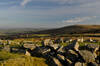
Minions is a village on the edge of Bodmin Moor that became famous during mediaeval times for The Cheesewring tor and The Hurlers stone circles. Somewhat more recently, following the Despicable Me films, the little yellow characters by the same name have made an appearance within the village on signs, buildings and even the official road signs. The moorland is rich in prehistoric remains and mining heritage.
-
5 miles/8 km - Easy-moderate
Minions and Caradon Hill

Minions and Caradon Hill
5 miles/8 km - Easy-moderate
A walk through the remains of the UK's most productive copper mines which employed thousands of people in Victorian times, including brakemen who each scooted an individual loaded ore wagon down to Liskeard on the railway that forms much of the walk route.
-
6.1 miles/9.8 km - Easy-moderate
Golitha Falls and Siblyback Lake

Golitha Falls and Siblyback Lake
6.1 miles/9.8 km - Easy-moderate
A circular walk through the Golitha Falls National Nature Reserve along ancient rights of way to pass around Siblyback Lake, where the remains of a mediaeval field system rise from the water when reservoir levels fall.
-
7.3 miles/11.7 km - Easy-moderate
Golitha Falls to Trethevy Quoit

Golitha Falls to Trethevy Quoit
7.3 miles/11.7 km - Easy-moderate
A circular walk through the Golitha Falls National Nature Reserve, to King Doniert's Stone - a memorial to the last King of Cornwall, and the prehistoric tomb of Trethevy Quoit, returning via St Cleer where the holy well is reputed to cure madness.
-
3.8 miles/6.8 km - Moderate
Minions and the Cheesewring

Minions and the Cheesewring
3.8 miles/6.8 km - Moderate
A circular walk around the iconic landmarks at Minions, including The Hurlers stone circles, The Cheesewring and the engine houses of the South Phoenix Mine.


Download the iWalk Cornwall app and use the QR scanner within the app to find out more about any of the walks above.
Two circular walks start at the village, one to The Cheesewring and another around Caradon Hill. The Golitha Falls National Nature Reserve is also nearby and two more circular walks start from there.
