
Walks in Cornwall visiting Heritage Trust sites
Enjoy the walks by being guided by the app


Circular walks visiting historic sites managed by the Cornwall Heritage Trust.
-
2.6 miles/4.2 km - Easy-moderate
Warbstow Cross and Bury

Warbstow Cross and Bury
2.6 miles/4.2 km - Easy-moderate
A fairly short and easy circular walk around Warbstow, crossing ramparts of the massive Iron Age hillfort, through fields and along country lanes lined with wildflowers, returning via the mediaeval church which is dedicated to the daughter of a Saxon King who was tutored by the Celtic Saint Morwenna.
-
3 miles/4.9 km - Easy-moderate
Baker's Pit and Rogers' Tower

Baker's Pit and Rogers' Tower
3 miles/4.9 km - Easy-moderate
A circular walk from the Bakers Pit nature reserve to an Iron Age hillfort where the remains of prehistoric roundhouses were seen as a convenient source of stone for a folly built in the era when the Poldark novels are set. The route crosses and circles the ramparts of the Castle An Dinas hillfort.
-
3.4 miles/5.5 km - Easy-moderate
Luxulyan Valley circular

Luxulyan Valley circular
3.4 miles/5.5 km - Easy-moderate
A circular walk following the leats and horse-drawn tramways through the World Heritage site of the Luxulyan Valley to the massive viaduct which carried the tramways towards Newquay and water to winch the trams up the valley with a huge waterwheel, recommended in guidebooks as early as the 1920s "as one of the most glorious walks in all Cornwall".
-
5.8 miles/9.3 km - Easy-moderate
Castle-an-dinas and Menalhyl valley

Castle-an-dinas and Menalhyl valley
5.8 miles/9.3 km - Easy-moderate
A mostly circular walk from the Castle-an-dinas Iron Age hillfort with 360 degree views across Cornwall, then into the valley to the River Menalhyl, followed by wooded paths lined with primroses, bluebells and wild garlic, and lanes with vibrant wildflowers.
-
7.3 miles/11.7 km - Easy-moderate
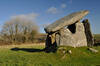
Golitha Falls to Trethevy Quoit

Golitha Falls to Trethevy Quoit
7.3 miles/11.7 km - Easy-moderate
A circular walk through the Golitha Falls National Nature Reserve, to King Doniert's Stone - a memorial to the last King of Cornwall, and the prehistoric tomb of Trethevy Quoit, returning via St Cleer where the holy well is reputed to cure madness.
-
3.7 miles/5.9 km - Moderate
Sancreed to Carn Euny

Sancreed to Carn Euny
3.7 miles/5.9 km - Moderate
A countryside walk to the Celtic church and Holy Well at Sancreed and the Iron Age village of Carn Euny where a well-preserved underground chamber known as a fogou has puzzled archaeologists for centuries As well as Carn Euny, the route includes Sancreed Beacon and passes Caer Barn.
-
3.8 miles/6.8 km - Moderate
Minions and the Cheesewring

Minions and the Cheesewring
3.8 miles/6.8 km - Moderate
A circular walk around the iconic landmarks at Minions, including The Hurlers stone circles, The Cheesewring and the engine houses of the South Phoenix Mine.
-
4.8 miles/7.8 km - Moderate
Godolphin to Tregonning

Godolphin to Tregonning
4.8 miles/7.8 km - Moderate
A circular walk from the mansion with possibly the oldest formal gardens in the country to two hills that altered the course of history, creating the wealthiest estate in Cornwall and giving rise to the Cornish China Clay industry.
-
4.8 miles/7.8 km - Moderate
Luxulyan Valley to Prideaux

Luxulyan Valley to Prideaux
4.8 miles/7.8 km - Moderate
A circular walk through the World Heritage site of the Luxulyan Valley and surrounding countryside, over the massive viaduct supporting a horse-drawn tram route to Newquay and along the leat that fed Charlestown Harbour.
-
5.8 miles/9.3 km - Moderate
Newquay

Newquay
5.8 miles/9.3 km - Moderate
A circular walk around the UK's surf capital which was transformed from a tiny fishing village with a few thatched cottages when, in order to export ore from the harbour, a horse-drawn tramway was built across Cornwall which later became part of the Great Western Railway. The route crosses East Pentire headland (inhabited since prehistoric times).
-
5.1 miles/8.2 km - Moderate-strenuous
Lamorna and St Loy

Lamorna and St Loy
5.1 miles/8.2 km - Moderate-strenuous
A circular walk visiting prehistoric stone circles, crosses and tombs and along the granite cliffs from Lamorna Cove to the sea-polished boulders of St Loy's Cove where sailors of a sinking vessel were able to climb to safety onto a large ship which had been wrecked there seven months before. The route includes the Tregiffian Barrow.
-
6.8 miles/10.9 km - Moderate-strenuous
Talland Bay to Looe

Talland Bay to Looe
6.8 miles/10.9 km - Moderate-strenuous
A circular walk along the coast from Talland Bay to Looe, passing the pilgrimage site of Looe Island which Jesus was said to have visited as a child, and returning via the ancient Giant's Hedge in Kilminorth Wood and Talland's mediaeval church. The route passes the remains of Lammana Chapel.


Download the iWalk Cornwall app and use the QR scanner within the app to find out more about any of the walks above.
