
Circular walks in Cornwall with wild garlic
Enjoy the walks by being guided by the app


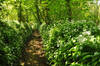
There is usually wild garlic (ramsons) along the route of these walks in the spring which is best foraged in March and April before it flowers in May and the leaves start to die back. Note that all plants from the onion family are poisonous to dogs so keep them away from wild garlic.
-
1.8 miles/2.9 km - Easy
The Camelford Way

The Camelford Way
1.8 miles/2.9 km - Easy
A short and easy circular walk from Camelford along the wildflower-rich meadows of the River Camel to the clapper bridge at Fenteroon, returning through the fields with views over the Camel Valley.
-
4.3 miles/6.9 km - Easy
Mawgan Porth to St Mawgan

Mawgan Porth to St Mawgan
4.3 miles/6.9 km - Easy
A mostly circular walk from Mawgan Porth along the Vale of Lanherne, following the river Menalhyl to St Mawgan and returning past the 800-year-old cloistered Convent where the sanctuary light has been burning for hundreds of years.
-
5.3 miles/8.5 km - Easy
Dunmere to Grogley Halt

Dunmere to Grogley Halt
5.3 miles/8.5 km - Easy
A circular walk along the Camel valley from Dunmere Halt to Grogley Halt on the Camel Trail, passing the Camel Valley vineyard and the Boscarne platform where the Bodmin-Wenford steam trains depart.
-
3.2 miles/5.1 km - Easy-moderate
Poundstock to Penfound

Poundstock to Penfound
3.2 miles/5.1 km - Easy-moderate
A circular walk along country lanes, tracks and through fields to Penfound Manor - thought to be the oldest continually-inhabited ancestral home in England - from Poundstock church and gildhouse - the only surviving mediaeval church house of its kind in Cornwall.
-
3.4 miles/5.5 km - Easy-moderate
Jacobstow to Poulza

Jacobstow to Poulza
3.4 miles/5.5 km - Easy-moderate
A circular countryside walk around the Saxon area of Jacobstow near Bude where an ancient mediaeval altar was removed from the church during the 16th Century and used as a footbridge over a stream, then used as a churchyard seat in Victorian times, and finally returned to the church in the 1970s.
-
3.5 miles/5.6 km - Easy-moderate
Mawnan
Mawnan
3.5 miles/5.6 km - Easy-moderate
A circular walk through three of the wooded valleys to the sheltered coves at the mouth of the Helford River
-
3.8 miles/6.1 km - Easy-moderate
St Clement and Malpas

St Clement and Malpas
3.8 miles/6.1 km - Easy-moderate
A circular walk at the confluence of the Truro and Tresillian rivers, once defended by Moresk castle and later where timber for the mines was unloaded and floated as rafts into Truro
-
3.8 miles/6.1 km - Easy-moderate
St Issey to Sea Mills

St Issey to Sea Mills
3.8 miles/6.1 km - Easy-moderate
A circular walk from St Issey along the river valley, the Saint's Way to the creek-side church at Little Petherick, and along the creek to the tidal enclosure of Sea Mills, returning via two old inns.
-
3.7 miles/5.9 km - Easy-moderate
St Mabyn to Pencarrow House

St Mabyn to Pencarrow House
3.7 miles/5.9 km - Easy-moderate
A fairly easy circular walk from St Mabyn past the church and through rolling countryside to Pencarrow House and its magnificent gardens.
-
4.1 miles/6.5 km - Easy-moderate
Mylor to Flushing

Mylor to Flushing
4.1 miles/6.5 km - Easy-moderate
A circular walk from Mylor Harbour along the creeks of Carrick Roads to Flushing which was named after a town in Holland when Dutch engineers built the quays, and where ships' captains would keep a watchful eye over Falmouth Harbour from their tall houses.
-
4.8 miles/7.7 km - Easy-moderate
Saltash and the Lynher Valley

Saltash and the Lynher Valley
4.8 miles/7.7 km - Easy-moderate
A circular walk in the ferry town that was the main riverside settlement in mediaeval times when Plymouth was moorland, and where a handful of Elizabethan buildings still remain from the period when Francis Drake built a property empire from his circumnavigation of the globe.
-
5 miles/8.1 km - Easy-moderate
Camelford to Watergate

Camelford to Watergate
5 miles/8.1 km - Easy-moderate
A circular walk from Camelford through bluebell woods along the Camel valley to the Celtic churchyard of Advent and the Neolithic remains on the edge of Bodmin Moor.
-
5.1 miles/8.2 km - Easy-moderate
Helford to Dennis Head

Helford to Dennis Head
5.1 miles/8.2 km - Easy-moderate
A circular walk around the creeks of the Helford River and the small villages settled by Celtic monks from Brittany.
-
5.2 miles/8.3 km - Easy-moderate
Tregantle to Crafthole
Tregantle to Crafthole
5.2 miles/8.3 km - Easy-moderate
A circular walk in tributary valleys of the St Germans River and past the Victorian coastal defences overlooking Whitsand Bay, where one of the forts is still in use today.
-
5.2 miles/8.4 km - Easy-moderate
Wadebridge to St Breock

Wadebridge to St Breock
5.2 miles/8.4 km - Easy-moderate
A circular walk from Wadebridge on the Camel Trail alongside the Amble Marshes nature reserve then across meadows and wooded creeks to the mediaeval church of St Breock, returning via the woods of the Polmorla valley.
-
5.3 miles/8.5 km - Easy-moderate
Lanhydrock to Restormel

Lanhydrock to Restormel
5.3 miles/8.5 km - Easy-moderate
A circular walk from the mediaeval bridge at Respryn along the River Fowey through the bluebell woodland of the Lanhydrock Estate to the circular Norman castle at Restormel which had a pressurised piped water system 700 years ahead of its time.
-
5.8 miles/9.3 km - Easy-moderate
Castle-an-dinas and Menalhyl valley

Castle-an-dinas and Menalhyl valley
5.8 miles/9.3 km - Easy-moderate
A mostly circular walk from the Castle-an-dinas Iron Age hillfort with 360 degree views across Cornwall, then into the valley to the River Menalhyl, followed by wooded paths lined with primroses, bluebells and wild garlic, and lanes with vibrant wildflowers.
-
6.1 miles/9.7 km - Easy-moderate
Egloshayle and Allen Valley

Egloshayle and Allen Valley
6.1 miles/9.7 km - Easy-moderate
A circular walk in the Allen Valley from Egloshayle though the broadleaf woodland alongside the River Allen past the mills of Hingham and Lemail to Dinham's Bridge, returning via the Celtic Three Holed Cross and the remains of Castle Killibury which from mediaeval Welsh texts is thought might be one of King Arthur's several castles.
-
6.2 miles/10 km - Easy-moderate
Widemouth to Bude

Widemouth to Bude
6.2 miles/10 km - Easy-moderate
A circular walk from Widemouth Bay along the Coast Path though the Phillips Point nature reserve to The Storm Tower at Compass Point and then along the Bude Canal to Whalesborough, returning across the fields to Widemouth.
-
6.6 miles/10.7 km - Easy-moderate
St Mawgan to St Columb Major

St Mawgan to St Columb Major
6.6 miles/10.7 km - Easy-moderate
A circular walk along the Vale of Lanherne to the mediaeval market town of St Columb Major, where Cornish Hurling is still played, through the broadleaf woodland of the Carnanton Estate along the River Menalhyl, returning to the riverside pub, church and convent at St Mawgan.
-
6.7 miles/10.8 km - Easy-moderate
Penryn Creeks and Enys

Penryn Creeks and Enys
6.7 miles/10.8 km - Easy-moderate
A circular walk along the creeks of Carrick Roads and through the woodland of the Enys Estate, famous for its bluebells in spring
-
6.8 miles/10.9 km - Easy-moderate
Wadebridge to Polbrock

Wadebridge to Polbrock
6.8 miles/10.9 km - Easy-moderate
A circular walk from Wadebridge through the Treraven nature reserve, bluebell woodland at Hustyn Mill and meadows along the River Camel to Polbrock, returning along the Camel Trail.
-
2.4 miles/3.9 km - Moderate
Palace Cove and Lansallos

Palace Cove and Lansallos
2.4 miles/3.9 km - Moderate
A circular walk to the small coves of Lantivet Bay used in Victorian times for pilchard fishing, collecting seaweed as fertiliser and smuggling barrels of French brandy.
-
2.6 miles/4.2 km - Moderate
Boscastle to Minster Church

Boscastle to Minster Church
2.6 miles/4.2 km - Moderate
A short circular walk from Boscastle through bluebell woodland alongside the River Valency to the ancient Celtic churchyard and sacred spring at Minster, returning along the River Jordan, beside which Bottreaux Castle was once situated, and Boscastle's Old Road.
-
2.8 miles/4.5 km - Moderate
Two Coombes of Lansallos

Two Coombes of Lansallos
2.8 miles/4.5 km - Moderate
A circular walk from Lansallos to the coves of Lantivet Bay where farmers collected seaweed and sand to improve the soil and smugglers landed French brandy.
-
3.3 miles/5.3 km - Moderate
Readymoney Cove to Polridmouth

Readymoney Cove to Polridmouth
3.3 miles/5.3 km - Moderate
A circular walk in du Maurier country from Readymoney Cove - where she lived in the 1940s - to Polridmouth, where the shipwreck inspired her book Rebecca.
-
3.6 miles/5.8 km - Moderate
Portwrinkle to Sheviock

Portwrinkle to Sheviock
3.6 miles/5.8 km - Moderate
A circular walk from the beach and tiny harbour of Portwrinkle to the small village of Sheviock, thought to be Cornish for "abounding in strawberries", with a church abounding in mediaeval tombs.
-
3.8 miles/6.1 km - Moderate
Helford and Frenchman's Creek

Helford and Frenchman's Creek
3.8 miles/6.1 km - Moderate
A circular walk through the wooded valleys of the Helford River including the most famous - Frenchman's Creek - which is still as pristine as when it inspired Daphne du Maurier's novel
-
4.2 miles/6.7 km - Moderate
Coombe and Old Kea

Coombe and Old Kea
4.2 miles/6.7 km - Moderate
A circular walk on the creeks of the Fal river network settled by Celtic monks where the ruin of a huge mediaeval church still towers above the trees
-
4.7 miles/7.6 km - Moderate
Fowey to Polridmouth

Fowey to Polridmouth
4.7 miles/7.6 km - Moderate
A figure-of-eight walk from Readymoney Cove past the Tudor fort and along the coast where Daphne du Maurier lived to Polridmouth, where the shipwreck inspired the end of her book Rebecca, and then along the mediaeval streets of Fowey.
-
5 miles/8 km - Moderate
Lantivet Bay and Lansallos

Lantivet Bay and Lansallos
5 miles/8 km - Moderate
A circular walk above the white sand crescent of Lantic Bay and the small coves of Lantivet Bay where a battle was once fought between smugglers and Customs men, and following an ancient cart track along the stream through the woods to the mediaeval church of Lansallos.
-
5.1 miles/8.2 km - Moderate
Lerryn to St Winnow

Lerryn to St Winnow
5.1 miles/8.2 km - Moderate
A circular walk to the creekside church of St Winnow along the River Fowey and Lerryn where hoards of Roman coins have been found on the river banks, and overlooked by the manor house that is thought may have been the inspiration for Toad Hall in The Wind in the Willows.
-
5.2 miles/8.4 km - Moderate
Bodmin and Bodiniel - the two manors

Bodmin and Bodiniel - the two manors
5.2 miles/8.4 km - Moderate
A figure-of-8 walk through Bodmin's historic centre to the beacon nature reserve and through the woods at Dunmere to Scarlett's Well
-
5.3 miles/8.6 km - Moderate
Little Petherick Creek and the Camel Trail

Little Petherick Creek and the Camel Trail
5.3 miles/8.6 km - Moderate
A circular walk via the Victorian obelisk overlooking Padstow, the creek-side church at Little Petherick and the tidal enclosure of Sea Mills, returning via the Camel Trail bridge which carried the railway that brought the first Victorian tourists to Padstow and Cornish fish to London.
-
5.3 miles/8.5 km - Moderate
Pendower Beach to Veryan

Pendower Beach to Veryan
5.3 miles/8.5 km - Moderate
A circular walk from Pendower Beach to Veryan via Nare Head where, in Victorian times, an unhappily married fisherman lived alone in a cliff-edge cottage, lowering his boat on a rope over the cliff and returning once a week to Veryan to bring his wife fish.
-
5.6 miles/9 km - Moderate
Delabole to Lanteglos

Delabole to Lanteglos
5.6 miles/9 km - Moderate
A circular walk through bluebell woodland, fields and along back lanes from Delabole to Camelford's parish church at Lanteglos, returning via the Iron Age forts of Castle Goff and Delinuth Camp.
-
5.8 miles/9.3 km - Moderate
Pelynt and the West Looe Valley

Pelynt and the West Looe Valley
5.8 miles/9.3 km - Moderate
A circular walk in the West Looe valley near St Nun's Well where it is said that if a bent pin is not left as an offering, clouds of piskies will accompany the visitor home and cause mischief.
-
6.1 miles/9.9 km - Moderate
Dunmere, Penhargard and Bodmin Jail

Dunmere, Penhargard and Bodmin Jail
6.1 miles/9.9 km - Moderate
A circular walk along the River Camel from Dunmere through bluebell woods and fields to Penhargard, and along an ancient route lined with wildflowers to Bodmin's historic jail.
-
6.5 miles/10.5 km - Moderate
Duloe to Herodsfoot

Duloe to Herodsfoot
6.5 miles/10.5 km - Moderate
A circular walk through the woodland along the West Looe River to Herodsfoot from Duloe, where Cornwall's smallest stone circle stands.
-
6.6 miles/10.6 km - Moderate
Inny Valleys from Altarnun

Inny Valleys from Altarnun
6.6 miles/10.6 km - Moderate
A circular walk around the valleys of the River Inny and Penpont Water to the mediaeval church at Laneast and the old bridge at Gimblett's Mill from the 15th century "Cathedral of the Moors" in Altarnun, set beside a 6th Century Celtic cross where churches and chapels had been throughout the Dark Ages.
-
7.6 miles/12.3 km - Moderate
Poldhu Cove to Cury

Poldhu Cove to Cury
7.6 miles/12.3 km - Moderate
A circular walk via some of the mediaeval farmsteads on the west of The Lizard to the ancient churchyard of Cury from the coves of Mullion and Gunwalloe where the wrecks of treasure ships still lie.
-
5 miles/8 km - Moderate-strenuous
Kilkhampton to the Coombe valley

Kilkhampton to the Coombe valley
5 miles/8 km - Moderate-strenuous
A circular walk though the wildflowers of the Kilkhampton Common nature reserve and woods of the Coombe Valley, returning via the remains of the Norman castle at Penstowe which consisted of a stone tower perched on the top of a steep hill but surrounded by two baileys, rather than the usual one, the reason for which is a mystery.
-
5 miles/8.1 km - Moderate-strenuous
Lerryn to St Veep

Lerryn to St Veep
5 miles/8.1 km - Moderate-strenuous
A circular walk from Lerryn, along wooded creeks and across fields, to the church of St Veep, which is the only one in England where the bells were cast in perfect tune.
-
5.4 miles/8.7 km - Moderate-strenuous
Boscastle to Buckator

Boscastle to Buckator
5.4 miles/8.7 km - Moderate-strenuous
A circular walk along the coastline from Boscastle via the Pentargon waterfall and the rugged cliffs at Buckator, returning along the Valency valley.
-
5.4 miles/8.6 km - Moderate-strenuous
Duckpool to Woodford

Duckpool to Woodford
5.4 miles/8.6 km - Moderate-strenuous
A circular walk in Morwenstow parish along towering cliffs and through broadleaf woods where a hamlet has been preserved in a joint project between the Landmark Trust and National Trust
-
6 miles/9.6 km - Moderate-strenuous
Seaton to Millendreath

Seaton to Millendreath
6 miles/9.6 km - Moderate-strenuous
A circular walk in an area of Cornwall so off the beaten track that No Man's Land is a real place name and a breeding colony of monkeys live in the woodland, in a sanctuary set up by the father of the classical guitarist, John Williams.
-
6.7 miles/10.8 km - Moderate-strenuous
Polkerris, Gribbin Head and Readymoney Cove

Polkerris, Gribbin Head and Readymoney Cove
6.7 miles/10.8 km - Moderate-strenuous
A circular walk near Fowey, from the tiny harbour of Polkerris, past the daymark tower on Gribbin Head and along the coast where Daphne du Maurier lived and based many of her books on, to the sandy beach at Readymoney Cove, returning on the Saint's Way.
-
7.1 miles/11.5 km - Strenuous
Polperro to Lansallos

Polperro to Lansallos
7.1 miles/11.5 km - Strenuous
A circular walk along the rugged coast from Polperro, where a bell buoy rings out across the waves from the treacherous reef known as Udder Rock.


Download the iWalk Cornwall app and use the QR scanner within the app to find out more about any of the walks above.
